IMAGES TAKEN NEAR TO
Clarendon Mews, BEXLEY, DA5 1JS
Introduction
This page details the photographs taken nearby to Clarendon Mews, DA5 1JS by members of the Geograph project.
The Geograph project started in 2005 with the aim of publishing, organising and preserving representative images for every square kilometre of Great Britain, Ireland and the Isle of Man.

There are currently over 7.5m images from over14,400 individuals and you can help contribute to the project by visiting https://www.geograph.org.uk
Image Map
Images are licensed for reuse under creativecommons.org/licenses/by-sa/2.0
Notes
- Clicking on the map will re-center to the selected point.
- The higher the marker number, the further away the image location is from the centre of the postcode.
Image Listing (115 Images Found)
Images are licensed for reuse under creativecommons.org/licenses/by-sa/2.0
Image
Details
Distance
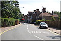
3

Traffic on Bexley High Street
Waiting at the roundabout with Bourne Way
Image: © David Howard
Taken: 6 Jan 2013
0.04 miles
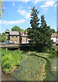
8
St Mary the Virgin churchyard, Bexley High Street
Image: © David Howard
Taken: 6 Jan 2013
0.05 miles
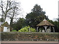
10
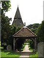
The northwest entrance to the churchyard of St Mary the Virgin
Image: © Mike Quinn
Taken: 11 Jun 2008
0.05 miles