IMAGES TAKEN NEAR TO
Basing Drive, BEXLEY, DA5 1ER
Introduction
This page details the photographs taken nearby to Basing Drive, DA5 1ER by members of the Geograph project.
The Geograph project started in 2005 with the aim of publishing, organising and preserving representative images for every square kilometre of Great Britain, Ireland and the Isle of Man.

There are currently over 7.5m images from over14,400 individuals and you can help contribute to the project by visiting https://www.geograph.org.uk
Image Map
Images are licensed for reuse under creativecommons.org/licenses/by-sa/2.0
Notes
- Clicking on the map will re-center to the selected point.
- The higher the marker number, the further away the image location is from the centre of the postcode.
Image Listing (20 Images Found)
Images are licensed for reuse under creativecommons.org/licenses/by-sa/2.0
Image
Details
Distance
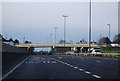
2
Arbuthnot Lane Bridge, East Rochester Way
The Rochester Way Relief Road section of the A2 was opened in 1988.
Image: © David Dixon
Taken: 15 May 2013
0.07 miles
4
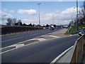
The A2 (Rochester Way) near Bexley, Kent
The A2 slashes west to east through this grid square like an angry knife. What do those petrolheads do with the extra seconds they save?
Image: © Dr Neil Clifton
Taken: 9 Apr 2006
0.12 miles

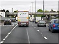
8

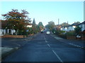
A2 East Rochester Way towards Bexley
As seen from Image
This busy dual carriage way leads from central London out to Kent, via Greenwich and Bexley.
Image: © David Anstiss
Taken: 15 Aug 2011
0.18 miles
9
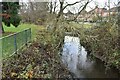
Along the Shuttle Riverway in springtime
This view looks upstream as the River Shuttle is marked here by the break in the mown grass where the two trees are in the middle of the picture. The Shuttle Riverway mostly follows linear parkland, as here, although a couple of hundred metres beyond where this photograph was taken, it goes through Bexley Park Wood. This wood rises up away from the river and this can be seen in the distance, to left of centre.
See https://www.geograph.org.uk/photo/6747780 for an account of a walk along the Shuttle Riverway.
Image: © Marathon
Taken: 15 Apr 2014
0.18 miles
10
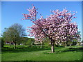
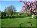
The Shuttle Riverway in spring
This view looks upstream as the River Shuttle is marked here by the break in the mown grass where the two trees are in the middle of the picture. The Shuttle Riverway mostly follows linear parkland, as here, although a couple of hundred metres beyond where this photograph was taken, it goes through Bexley Park Wood. This wood rises up away from the river and this can be seen in the distance, to left of centre.
See https://www.geograph.org.uk/photo/6747780 for an account of a walk along the Shuttle Riverway.
Image: © Marathon
Taken: 15 Apr 2014
0.18 miles