IMAGES TAKEN NEAR TO
Knoll Road, BEXLEY, DA5 1BB
Introduction
This page details the photographs taken nearby to Knoll Road, DA5 1BB by members of the Geograph project.
The Geograph project started in 2005 with the aim of publishing, organising and preserving representative images for every square kilometre of Great Britain, Ireland and the Isle of Man.

There are currently over 7.5m images from over14,400 individuals and you can help contribute to the project by visiting https://www.geograph.org.uk
Image Map
Images are licensed for reuse under creativecommons.org/licenses/by-sa/2.0
Notes
- Clicking on the map will re-center to the selected point.
- The higher the marker number, the further away the image location is from the centre of the postcode.
Image Listing (68 Images Found)
Images are licensed for reuse under creativecommons.org/licenses/by-sa/2.0
Image
Details
Distance

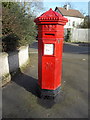
3
Penfold postbox, Parkhill Road - royal cipher and crest
See Image
Image: © Mike Quinn
Taken: 11 Jun 2008
0.14 miles
4

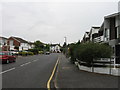
Houses in Parkhurst Road/Parkhurst Gardens
Shows the location of Image
Image: © Mike Quinn
Taken: 11 Jun 2008
0.14 miles
5
Penfold postbox, Parkhill Road
Image: © Mike Quinn
Taken: 11 Jun 2008
0.14 miles

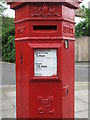
7

Penfold postbox, Bexley
Another view at Image
See also this http://www.postalheritage.org.uk/explore/history/letterboxes/
Image: © Jim Osley
Taken: 31 Oct 2015
0.15 miles
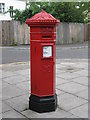
8
Bexley: postbox № DA5 67, Parkhill Road
A well-painted hexagonal 'Penfold' design, the predecessor to the cylindrical form which has been standard since the late 1870s.
Image: © Chris Downer
Taken: 2 Feb 2015
0.15 miles
9
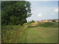
The Shuttle Riverway
The River Shuttle which runs from Avery Hill Park to join the River Cray near Hall Place is followed by the Shuttle Riverway. The river is in the vegetation to the left. This view looks upriver towards the new houses of Bayn Close.
See https://www.geograph.org.uk/photo/6747780 for an account of a walk along the Shuttle Riverway.
Image: © Marathon
Taken: 24 Jul 2010
0.17 miles
10
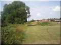
Part of the Shuttle Riverway
The Shuttle Riverway leads through a series of small parks which have remained undeveloped because of their proximity to the River Shuttle. This photograph is looking upstream towards the new houses in Bayn Close, and the Shuttle is flowing through the dense vegetation on the left.
See https://www.geograph.org.uk/photo/6747780 for an account of a walk along the Shuttle Riverway.
Image: © Marathon
Taken: 24 Jul 2010
0.18 miles