IMAGES TAKEN NEAR TO
Claytonville Terrace, Crabtree Manorway North, BELVEDERE, DA17 6AQ
Introduction
This page details the photographs taken nearby to Claytonville Terrace, Crabtree Manorway North, DA17 6AQ by members of the Geograph project.
The Geograph project started in 2005 with the aim of publishing, organising and preserving representative images for every square kilometre of Great Britain, Ireland and the Isle of Man.

There are currently over 7.5m images from over14,400 individuals and you can help contribute to the project by visiting https://www.geograph.org.uk
Image Map
Images are licensed for reuse under creativecommons.org/licenses/by-sa/2.0
Notes
- Clicking on the map will re-center to the selected point.
- The higher the marker number, the further away the image location is from the centre of the postcode.
Image Listing (17 Images Found)
Images are licensed for reuse under creativecommons.org/licenses/by-sa/2.0
Image
Details
Distance
1
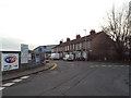
Houses on Crabtree Manorway, Belvedere
A housing terrace on Crabtree Manorway in Belvedere.
This part of Belvedere is mainly industrial, rather than residential.
Image: © Malc McDonald
Taken: 30 Dec 2017
0.01 miles
2
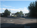
Roundabout on Crabtree Manorway North
The Manorway becomes South, the other side of the junction before being cut in half by the Bronze Age Way.
Mulberry Way heads left through Belvedere Industrial Estate.
Anderson Way heads right towards Picardy Manorway.
Image: © David Anstiss
Taken: 21 Aug 2011
0.02 miles
3
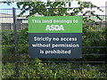
Confusing sign
This sign on Anderson Way on the Belvedere industrial Estate is repeated several times along the fence. No access is prohibited - so feel free to come in!
Update in 2024 - these signs have been removed.
Image: © Marathon
Taken: 5 May 2022
0.07 miles
4
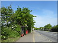
Bus stop on Anderson Way
Route 180 from Lewisham to Belvedere Industrial area terminates near here. This is one of its first stops on the way back towards Lewisham.
Image: © Marathon
Taken: 4 May 2018
0.07 miles
5
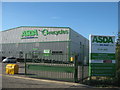
Asda Recycling Site, Belvedere
On Crabtree Manorway North.
Image: © David Anstiss
Taken: 21 Aug 2011
0.07 miles
6
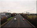
A2016 Bronze Age Way towards The Cob
As seen from Image
This dual carriageway leads from Dartford past Erith towards Thamesmead and Woolwich.
In the background is the roundabout and Image
Image: © David Anstiss
Taken: 27 Feb 2012
0.11 miles
7
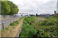
Drain Beside Mulberry Way
Clearly this area was once marshland
Image: © Glyn Baker
Taken: 23 Apr 2017
0.13 miles
8
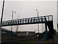
Footbridge on Crabtree Manorway South
This bridge leads from the industrial estates on Crabtree Manorway South and near the River Thames, towards Mitchel Close, Belvedere.
It passes over the A2016 Bronze Age Way (dual carriageway).
Image: © David Anstiss
Taken: 27 Feb 2012
0.13 miles
9
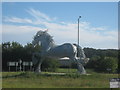
The Cob sculpture, Belvedere
Image: © David Anstiss
Taken: 21 Aug 2011
0.15 miles
10
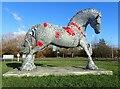
The Cob at Belvedere
This striking sculpture is in the middle of the busy roundabout at the junction of Bronze Age Way (A2016) and Picardy Manorway in Belvedere. It was created by Scottish sculptor Andy Scott who brought his specially commissioned steel statue of a gipsy cob horse down in pieces from his Glasgow studio at the beginning of 2011, stopping in Telford for the millions of steel pieces which make up the statue to be galvanised.
See http://www.geograph.org.uk/photo/2314583 for another impressive horse sculpture by Andy Scott, this time in Glasgow.
Image: © Marathon
Taken: 20 Jan 2022
0.15 miles