IMAGES TAKEN NEAR TO
Park View Road, WELLING, DA16 1TB
Introduction
This page details the photographs taken nearby to Park View Road, DA16 1TB by members of the Geograph project.
The Geograph project started in 2005 with the aim of publishing, organising and preserving representative images for every square kilometre of Great Britain, Ireland and the Isle of Man.

There are currently over 7.5m images from over14,400 individuals and you can help contribute to the project by visiting https://www.geograph.org.uk
Image Map
Images are licensed for reuse under creativecommons.org/licenses/by-sa/2.0
Notes
- Clicking on the map will re-center to the selected point.
- The higher the marker number, the further away the image location is from the centre of the postcode.
Image Listing (39 Images Found)
Images are licensed for reuse under creativecommons.org/licenses/by-sa/2.0
Image
Details
Distance
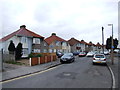
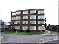
2
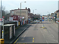
A207 Park View Road
At the Guy, Earl of Warwick bus stop, named after a pub down the road just past the large block in the left.
Image: © Robin Webster
Taken: 14 Mar 2012
0.03 miles
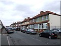
6
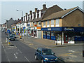
Premises on A207 Park View Road
A bit further along the road becomes Welling High Street.
Image: © Robin Webster
Taken: 14 Mar 2012
0.05 miles
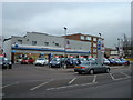
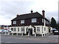
10
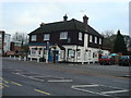
Guy Earl of Warwick Public House, Welling
Image: © Stacey Harris
Taken: 14 Dec 2008
0.06 miles