IMAGES TAKEN NEAR TO
Douglas Road, WELLING, DA16 1QY
Introduction
This page details the photographs taken nearby to Douglas Road, DA16 1QY by members of the Geograph project.
The Geograph project started in 2005 with the aim of publishing, organising and preserving representative images for every square kilometre of Great Britain, Ireland and the Isle of Man.

There are currently over 7.5m images from over14,400 individuals and you can help contribute to the project by visiting https://www.geograph.org.uk
Image Map
Images are licensed for reuse under creativecommons.org/licenses/by-sa/2.0
Notes
- Clicking on the map will re-center to the selected point.
- The higher the marker number, the further away the image location is from the centre of the postcode.
Image Listing (36 Images Found)
Images are licensed for reuse under creativecommons.org/licenses/by-sa/2.0
Image
Details
Distance
1
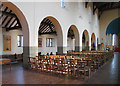
St Michael, Upper Wickham Lane, East Wickham - Arcade
Image: © John Salmon
Taken: 19 Mar 2005
0.07 miles
2
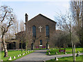
St Michael, Upper Wickham Lane, East Wickham
Image: © John Salmon
Taken: 19 Mar 2005
0.07 miles
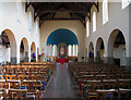
3
St Michael, Upper Wickham Lane, East Wickham
Image: © John Salmon
Taken: 19 Mar 2005
0.07 miles
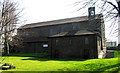
4
St Michael, Upper Wickham Lane, East Wickham - North aisle
Image: © John Salmon
Taken: 19 Mar 2005
0.07 miles
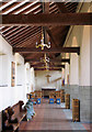
5
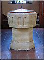
St Michael, Upper Wickham Lane, East Wickham - Font
Image: © John Salmon
Taken: 19 Mar 2005
0.07 miles
6
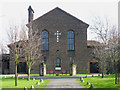
St Michael, Upper Wickham Lane, East Wickham
Image: © John Salmon
Taken: 19 Mar 2005
0.07 miles
7
St Michael, Upper Wickham Lane, East Wickham
Image: © John Salmon
Taken: 19 Mar 2005
0.08 miles
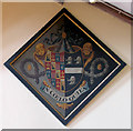
8
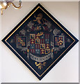
St Michael, Upper Wickham Lane, East Wickham - St Michael, Upper Wickham Lane, East Wickham - Hatchment
Image: © John Salmon
Taken: 19 Mar 2005
0.08 miles
9

St Michael, Upper Wickham Lane, East Wickham - Royal Arms
Image: © John Salmon
Taken: 19 Mar 2005
0.08 miles
10
St Michael, Upper Wickham Lane, East Wickham - Hatchment
Image: © John Salmon
Taken: 19 Mar 2005
0.08 miles