IMAGES TAKEN NEAR TO
Gipsy Road, WELLING, DA16 1JJ
Introduction
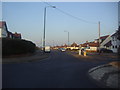
This page details the photographs taken nearby to Gipsy Road, DA16 1JJ by members of the Geograph project.
The Geograph project started in 2005 with the aim of publishing, organising and preserving representative images for every square kilometre of Great Britain, Ireland and the Isle of Man.

There are currently over 7.5m images from over14,400 individuals and you can help contribute to the project by visiting https://www.geograph.org.uk
Image Map
Images are licensed for reuse under creativecommons.org/licenses/by-sa/2.0
Notes
- Clicking on the map will re-center to the selected point.
- The higher the marker number, the further away the image location is from the centre of the postcode.
Image Listing (21 Images Found)
Images are licensed for reuse under creativecommons.org/licenses/by-sa/2.0
Image
Details
Distance
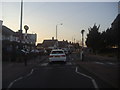
1
Brampton Road at the junction of Long Lane
Image: © David Howard
Taken: 11 Mar 2012
0.06 miles
2
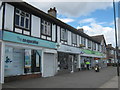
Shops on Brampton Road
Opposite Long Lane.
Includes a Co-Operative Supermarket and Pharmacy.
Image: © David Anstiss
Taken: 7 Aug 2011
0.07 miles
3
Brampton Road approaching the roundabout
Image: © David Howard
Taken: 11 Mar 2012
0.09 miles
4
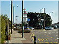
Brampton Road, Long Lane bus stop
This is right by the mini-roundabout where the two roads diverge. As well as a bus stop for route B11 towards Bexleyheath, it is also a coach stop for Ebdons, according to the sign.
Image: © Robin Webster
Taken: 15 Mar 2012
0.09 miles
5
King Harolds Way, Bexleyheath
From the roundabout on Brampton Road
Image: © David Howard
Taken: 11 Mar 2012
0.12 miles
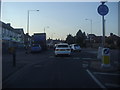
6
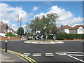
Roundabout on Brampton Road
Brampton Road leads from Bexleyheath, straight on towards West Heath.
King Harold's Way leads right towards Lessness Heath.
Okehampton Crescent leads left towards East Wickham.
Image: © David Anstiss
Taken: 7 Aug 2011
0.12 miles
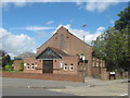
7
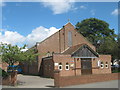
St. Thomas More Catholic Church, West Heath (2)
On the junction of Long Lane (in front) and Bostall Park Avenue (on the right).
Image: © David Anstiss
Taken: 7 Aug 2011
0.14 miles
8
St. Thomas More Catholic Church, West Heath
On the junction of Long Lane (in front) and Bostall Park Avenue (on the right).
Image: © David Anstiss
Taken: 7 Aug 2011
0.14 miles
9
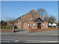
St. Thomas More Catholic Church
On Long Lane.
Image: © Robin Webster
Taken: 15 Mar 2012
0.14 miles
10
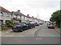
Bostall Park Avenue, near Bexleyheath
Bostall Park Avenue is a residential road in the outer suburbs of south east London.
Image: © Malc McDonald
Taken: 14 Jul 2019
0.16 miles