IMAGES TAKEN NEAR TO
Shield Road, DARTFORD, DA1 5UR
Introduction
This page details the photographs taken nearby to Shield Road, DA1 5UR by members of the Geograph project.
The Geograph project started in 2005 with the aim of publishing, organising and preserving representative images for every square kilometre of Great Britain, Ireland and the Isle of Man.

There are currently over 7.5m images from over14,400 individuals and you can help contribute to the project by visiting https://www.geograph.org.uk
Image Map
Images are licensed for reuse under creativecommons.org/licenses/by-sa/2.0
Notes
- Clicking on the map will re-center to the selected point.
- The higher the marker number, the further away the image location is from the centre of the postcode.
Image Listing (33 Images Found)
Images are licensed for reuse under creativecommons.org/licenses/by-sa/2.0
Image
Details
Distance
2
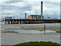
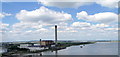
Littlebrook Power Station, 2011
Beyond a jetty on the Purfleet side.
Image: © Robin Webster
Taken: 19 Jun 2011
0.12 miles
3
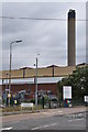
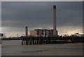
Littlebrook Power Station
The large oil fired power station is owned and run by npower, it is currently in reserve. http://en.wikipedia.org/wiki/Littlebrook_Power_Station
Image: © Ashley Dace
Taken: 30 Sep 2010
0.13 miles
4
View from the Kent side of the QEII Bridge #3
A little downstream from the QEII Bridge, the river course curves sharply, allowing travellers on the bridge to see across to the Essex bank for the first time since the beginning of the bridge in Thurrock. Another power station is visible just below the arm of the pylon, and many ports and docksides near the Wennington Marshes can be seen. View taken from the same lookout as http://www.geograph.org.uk/photo/1428628 but again, taken from further along the QEII Bridge towards the toll booths.
Image: © Robert Lamb
Taken: 18 Jul 2009
0.16 miles
5
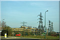
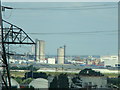
Pylons and switchgear, Littlebrook Power Station
The nearest pylon is rather odd, as the cables attached are dead ends at each end, as far as can be discerned. The next similar pylon supports cables with links attached.
Image: © Robin Webster
Taken: 1 Mar 2012
0.17 miles
6
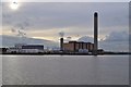
Jetties and Power station near Dartford
Image: © nick macneill
Taken: 1 Jul 2011
0.18 miles
8
View from the QEII Bridge
Looking to the west over Littlebrook Power Station.
Image: © Trevor Harris
Taken: 11 Jul 2009
0.19 miles
9
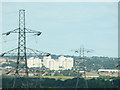
View from the Kent side of the QEII Bridge #2
Taken a little further along the QEII Bridge from http://www.geograph.org.uk/photo/1428611, in square TQ5675 and looking west-northwest, the focal point in this shot is the flats in the middle distance which, as far as I can make out, are on the border of the Littlebrook Nature Park. The pylons here add an interesting emphasis on the perspective.
Image: © Robert Lamb
Taken: 18 Jul 2009
0.19 miles
10
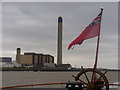
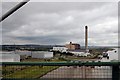
Littlebrook Power Station
Landmark chimney at the Thamesside power station just west of the QE2 Bridge. Taken from the deck of PS Waverley.
Image: © Colin Smith
Taken: 26 Sep 2010
0.19 miles