IMAGES TAKEN NEAR TO
Ridgeway West, SIDCUP, DA15 8SF
Introduction
This page details the photographs taken nearby to Ridgeway West, DA15 8SF by members of the Geograph project.
The Geograph project started in 2005 with the aim of publishing, organising and preserving representative images for every square kilometre of Great Britain, Ireland and the Isle of Man.

There are currently over 7.5m images from over14,400 individuals and you can help contribute to the project by visiting https://www.geograph.org.uk
Image Map
Images are licensed for reuse under creativecommons.org/licenses/by-sa/2.0
Notes
- Clicking on the map will re-center to the selected point.
- The higher the marker number, the further away the image location is from the centre of the postcode.
Image Listing (57 Images Found)
Images are licensed for reuse under creativecommons.org/licenses/by-sa/2.0
Image
Details
Distance
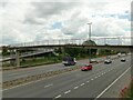
2
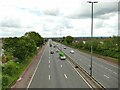
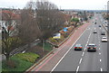
The A2 eastbound at Falconwood
Looking down from a footbridge Image
Image: © Stephen Craven
Taken: 31 May 2022
0.09 miles
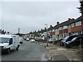
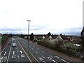
4
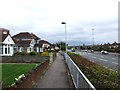
Ridgeway West, Falconwood
Ridgeway West is a residential road in the suburbs of South East London.
Image: © Malc McDonald
Taken: 15 Mar 2014
0.10 miles
7
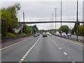
East Rochester Way (A2), Footbridge at Falconwood
The Rochester Way Relief Road section of the A2 was opened in 1988.
Image: © David Dixon
Taken: 15 May 2013
0.11 miles
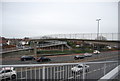
10
Footbridge over the A2 at Falconwood
The A2 is known as Rochester Way at this point.
Image: © Stephen Craven
Taken: 31 May 2022
0.12 miles