
IMAGES TAKEN NEAR TO
Orchard Rise East, SIDCUP, DA15 8RT
Introduction
This page details the photographs taken nearby to Orchard Rise East, DA15 8RT by members of the Geograph project.
The Geograph project started in 2005 with the aim of publishing, organising and preserving representative images for every square kilometre of Great Britain, Ireland and the Isle of Man.

There are currently over 7.5m images from over14,400 individuals and you can help contribute to the project by visiting https://www.geograph.org.uk
Image Map
Images are licensed for reuse under creativecommons.org/licenses/by-sa/2.0
Notes
- Clicking on the map will re-center to the selected point.
- The higher the marker number, the further away the image location is from the centre of the postcode.
Image Listing (54 Images Found)
Images are licensed for reuse under creativecommons.org/licenses/by-sa/2.0
Image
Details
Distance



10
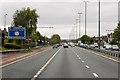
East Rochester Way (A2) Welling
The large sign on the left gives advance warning of height and width restrictions on the Blackwall Tunnel. The sign is blue rather than green as might be expected on a trunk road such as the A2. This is because there are motorway restrictions (no Pedestrians, no stopping etc) on both stretches of what were the A102M* (now simply A102) through the tunnel.
* NOTE: Following the formation of Transport for London (TfL), the A102(M) road was reclassified in May 2000. This change was required because the Greater London Authority (GLA) Act does not give the Mayor for London powers to be the highway authority for motorways, but these roads were being transferred to the Mayor. It was therefore necessary to remove their motorway status before June 2000 when the Mayor took office. The Blackwall Tunnel Southern Approach road is now simply a section of A102 (http://www.ciht.org.uk/motorway/a102mbtapp.htm The Motorway Archive).
Image: © David Dixon
Taken: 15 May 2013
0.10 miles