IMAGES TAKEN NEAR TO
Croyde Close, SIDCUP, DA15 8DU
Introduction
This page details the photographs taken nearby to Croyde Close, DA15 8DU by members of the Geograph project.
The Geograph project started in 2005 with the aim of publishing, organising and preserving representative images for every square kilometre of Great Britain, Ireland and the Isle of Man.

There are currently over 7.5m images from over14,400 individuals and you can help contribute to the project by visiting https://www.geograph.org.uk
Image Map
Images are licensed for reuse under creativecommons.org/licenses/by-sa/2.0
Notes
- Clicking on the map will re-center to the selected point.
- The higher the marker number, the further away the image location is from the centre of the postcode.
Image Listing (27 Images Found)
Images are licensed for reuse under creativecommons.org/licenses/by-sa/2.0
Image
Details
Distance
1
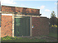
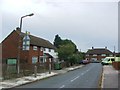
Substation (1931) on Halfway Street
A fine example of a utility building, with the date (1931) above the ornate doorway. A pity that the original doors have been replaced with boring industrial steel shutters.
Image: © Stephen Craven
Taken: 25 Oct 2009
0.04 miles
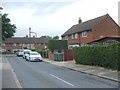
2
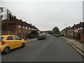
Houses on Halfway Street
A fine pair of houses on the B2214 at Avery Hill.
Image: © Stephen Craven
Taken: 25 Oct 2009
0.04 miles
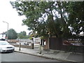
7
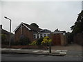
Avery Hill Christian Fellowship Church
Image: © David Howard
Taken: 30 Aug 2015
0.08 miles
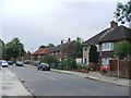
9
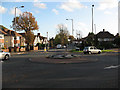
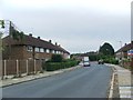
Roundabout on Avery Hill Road
The roundabout is at the junction with Halfway Street.
Image: © Stephen Craven
Taken: 25 Oct 2009
0.09 miles
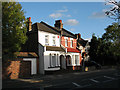
10
The Black Boy on Southspring, Blackfen
Image: © David Howard
Taken: 30 Aug 2015
0.09 miles