IMAGES TAKEN NEAR TO
Woodfall Drive, DARTFORD, DA1 4TR
Introduction
This page details the photographs taken nearby to Woodfall Drive, DA1 4TR by members of the Geograph project.
The Geograph project started in 2005 with the aim of publishing, organising and preserving representative images for every square kilometre of Great Britain, Ireland and the Isle of Man.

There are currently over 7.5m images from over14,400 individuals and you can help contribute to the project by visiting https://www.geograph.org.uk
Image Map
Images are licensed for reuse under creativecommons.org/licenses/by-sa/2.0
Notes
- Clicking on the map will re-center to the selected point.
- The higher the marker number, the further away the image location is from the centre of the postcode.
Image Listing (32 Images Found)
Images are licensed for reuse under creativecommons.org/licenses/by-sa/2.0
Image
Details
Distance
1
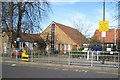
Crayford: St Paulinus CE Primary School
The School is on the north side of Iron Mill Lane and was opened on this site in 1974 with various later additions. The pitched roofs of these buildings extend to ground level. The School's website is here http://www.st-paulinus.bexley.sch.uk/default.htm
Image: © Nigel Cox
Taken: 2 Mar 2008
0.18 miles
2
Crayford: Iron Mill Lane
Viewed at its junction with Iron Mill Place with the ever-present landmark of the Littlebrook Power Station chimney visible in the distance.
Image: © Nigel Cox
Taken: 2 Mar 2008
0.18 miles
3

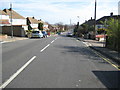
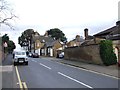
Crayford Way, Crayford
Crayford Way links Crayford and Barnes Cray. Most of the houses along it are similar to these.
Image: © David Kemp
Taken: 15 Nov 2008
0.20 miles
4
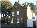
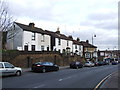
Victorian houses in Iron Mill Lane, Crayford
These houses are seen from Iron Mill Lane. The plaque on the wall gives their date as 1865.
Image: © Marathon
Taken: 24 Jun 2011
0.20 miles
5
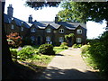
Crayford Parish Office, Iron Mill Lane
At the western end of Iron Mill Lane, there is an attractive group of buildings including St Paulinus Church and the Parish Office dating from 1865 seen here.
Image: © Marathon
Taken: 8 Feb 2011
0.20 miles
7
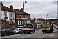
High Street Crayford
Looking East towards the town centre.
Cottages on the left of the photograph identified as 'Grove Place - 1841'
Image: © Brian Chadwick
Taken: 19 Aug 2010
0.22 miles
8
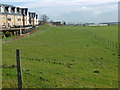
View from Perry Street
Much of the horse-grazed grassland ahead is landfill from old quarries. The development on the left is fairly recent. The Queen Elizabeth II Bridge with its twin white piers can be seen in the distance and on either side of the right hand piers are the twin pylons at West Thurrock (to the left) and Swanscombe (to the right). At 623 feet these are the tallest pylons in the United Kingdom and the second tallest in Europe - see http://www.geograph.org.uk/photo/1669476
Image: © Marathon
Taken: 2 Feb 2016
0.22 miles
10
The interior of St Paulinus, Crayford
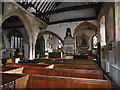
The nave of St Paulinus has a west tower of the 15th century and a north aisle which is as wide as the nave, a chancel and two side chapels to the chancel. Although all the windows were renewed in Victorian times there is evidence that a church was here in Norman times. This includes the window on the right here above the brass plaque which was clearly Norman. A better view from outside can be seen at http://www.geograph.org.uk/photo/4813349 John Newman in Pevsner's Building of England: West Kent and the Weald says that although there is Norman work in both the nave and the north aisle, he concludes that what is now the north aisle was the original church. This leaves a most strange interior with the arcade dividing the nave from the north aisle running right down the middle of the church. It gives the impression now of two naves.
This view from just inside the south door looks across from the current nave towards the chancel with the original nave on the left.
The churchyard is a 'living churchyard' which means it is infrequently mown and largely kept as a nature reserve, although it is still tidy. The churchyard and church together give the impression of the country churchyard that this once was. A large memorial garden has recently been opened to the north of the churchyard.
Some more information can be found at http://www.bexley.gov.uk/article/11201/St-Paulinus-Church
Image: © Marathon
Taken: 2 Feb 2016
0.23 miles