
IMAGES TAKEN NEAR TO
Virginia Road, DARTFORD, DA1 4FS
Introduction
This page details the photographs taken nearby to Virginia Road, DA1 4FS by members of the Geograph project.
The Geograph project started in 2005 with the aim of publishing, organising and preserving representative images for every square kilometre of Great Britain, Ireland and the Isle of Man.

There are currently over 7.5m images from over14,400 individuals and you can help contribute to the project by visiting https://www.geograph.org.uk
Image Map
Images are licensed for reuse under creativecommons.org/licenses/by-sa/2.0
Notes
- Clicking on the map will re-center to the selected point.
- The higher the marker number, the further away the image location is from the centre of the postcode.
Image Listing (63 Images Found)
Images are licensed for reuse under creativecommons.org/licenses/by-sa/2.0
Image
Details
Distance
1

Junction of Maiden Lane with Crayford Way - Crayford
An increasingly busy junction although there is a railway bridge which restricts height and width on Maiden Lane which joins the Dartford Road ( A226 ).
Image: © Brian Chadwick
Taken: 19 Aug 2009
0.03 miles
2
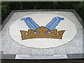
Logo from demolished Vicker's factory
Image: © Alex McGregor
Taken: 16 Aug 2013
0.03 miles
3

Samas Roneo building - vandalised and then demolished
Following the vandalism the building is now being demolished to make way for a housing development. See Image
Image: © Brian Chadwick
Taken: 1 Oct 2009
0.03 miles
4

Disused Building Vandalised
Situated in Maiden Lane, Dartford to the north of the A226 (Dartford Road). This building, which appeared to be in good condition at the time when it was vacated by Samas Roneo five years ago, has been consistently vandalised. Demolition work is now in progress (August 2009) to the rear of the building.
Image]
Image: © Brian Chadwick
Taken: 19 Aug 2009
0.04 miles
5

Samas Roneo - Maiden Lane Crayford - Demolition almost complete
See photographs Image and Image to see earlier stages of the demolition to make way for new housing.
Image: © Brian Chadwick
Taken: 11 Nov 2009
0.04 miles
6

Derelict Site Recovering
Earlier Geographs (Image etc.) show this as a demolition site.
It's now a grassy meadow waiting for whatever the planners have in store.
Image: © Des Blenkinsopp
Taken: 4 Jun 2015
0.04 miles

8

Narrow bridge in Maiden Lane, Crayford
This is not the easiest bridge for cars to negotiate, but they usually manage. Never widened since it was built, vehicles have to approach almost up to it before checking the way ahead is clear or giving way.
Image: © Marathon
Taken: 27 Feb 2011
0.06 miles
9

Coal Tax post and narrow bridge, Maiden Lane, Crayford
On the right of the photograph in its setting can be seen one of the City of London Coal Tax posts. Coal Tax posts were marker posts, first erected in 1851 and forming a rough circle about twenty miles from the centre of London to mark the points where taxes on coal and wine due to the Corporation of London had to be paid. Of the original 250 or so, approximately 200 have survived. The bridge itself is not the easiest bridge for cars to negotiate, but they usually manage. Never widened since it was built and the twist in the road underneath not helping, vehicles have to approach almost up to it before checking the way ahead is clear or giving way.
Image: © Marathon
Taken: 27 Feb 2011
0.06 miles
10

Maiden Lane bridge, Crayford
The bridge under the railway in Maiden Lane is not the easiest bridge for cars to negotiate, but they usually manage. Never widened since it was built and the twist in the road underneath not helping, vehicles have to approach almost up to it before checking the way ahead is clear or giving way. It is well-used though as there is no other road crossing the railway between the centre of Crayford and the centre of Dartford. See also http://www.geograph.org.uk/photo/2332956
Image: © Marathon
Taken: 27 Feb 2011
0.06 miles