IMAGES TAKEN NEAR TO
Tanners Close, DARTFORD, DA1 4FB
Introduction
This page details the photographs taken nearby to Tanners Close, DA1 4FB by members of the Geograph project.
The Geograph project started in 2005 with the aim of publishing, organising and preserving representative images for every square kilometre of Great Britain, Ireland and the Isle of Man.

There are currently over 7.5m images from over14,400 individuals and you can help contribute to the project by visiting https://www.geograph.org.uk
Image Map
Images are licensed for reuse under creativecommons.org/licenses/by-sa/2.0
Notes
- Clicking on the map will re-center to the selected point.
- The higher the marker number, the further away the image location is from the centre of the postcode.
Image Listing (11 Images Found)
Images are licensed for reuse under creativecommons.org/licenses/by-sa/2.0
Image
Details
Distance
1

Apartment block on Perry Street, near Dartford
A recently-built apartment block on Perry Street, on the outermost fringe of south east London.
Image: © Malc McDonald
Taken: 14 Jul 2019
0.05 miles
3
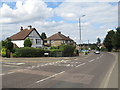
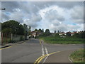
Perry Street, near Dartford
Perry Street forms part of the A2000 road on the outer fringe of south east London.
Image: © Malc McDonald
Taken: 14 Jul 2019
0.11 miles
4
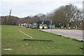
View from Perry Street
Much of the horse-grazed grassland ahead is landfill from old quarries. The development on the left is fairly recent. The Queen Elizabeth II Bridge with its twin white piers can be seen in the distance and on either side of the right hand piers are the twin pylons at West Thurrock (to the left) and Swanscombe (to the right). At 623 feet these are the tallest pylons in the United Kingdom and the second tallest in Europe - see http://www.geograph.org.uk/photo/1669476
Image: © Marathon
Taken: 2 Feb 2016
0.13 miles
5
Holmsdale Grove, Barnehurst
Holmsdale Grove is a residential road in Barnehurst, on the outermost fringe of south east London.
Image: © Malc McDonald
Taken: 14 Jul 2019
0.15 miles
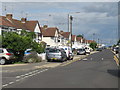
6
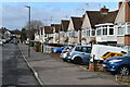
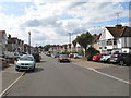
Parked cars in Holmsdale Grove
Typical of the smaller 1930s house designs in this area, built as short terraces. The lack of driveways has led to most front gardens being converted to off-street parking.
Image: © David Martin
Taken: 16 Feb 2022
0.18 miles
8
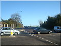
Road junction on Gascoyne Drive
Leading from Sheerwood Crescent, towards Wyatt Road. On the right Wyatt Road leads towards the A206 roundabout.
Image: © David Anstiss
Taken: 7 Aug 2011
0.24 miles
9
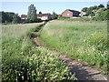
Footpath leading to Wyatt Road, Barnehurst
Looking up from the roundabout at the junction of Perry Street and Northend Road, this footpath provides a short cut.
Image: © Marathon
Taken: 15 Jun 2010
0.24 miles
10
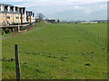
Parkside Avenue, Barnehurst
Parkside Avenue in barnehurst, on the outer fringe of south east London. Just visible in the Queen Elizabeth II Bridge which links Kent with Essex.
Image: © Malc McDonald
Taken: 14 Jul 2019
0.24 miles