IMAGES TAKEN NEAR TO
Bedens Road, SIDCUP, DA14 5JQ
Introduction
This page details the photographs taken nearby to Bedens Road, DA14 5JQ by members of the Geograph project.
The Geograph project started in 2005 with the aim of publishing, organising and preserving representative images for every square kilometre of Great Britain, Ireland and the Isle of Man.

There are currently over 7.5m images from over14,400 individuals and you can help contribute to the project by visiting https://www.geograph.org.uk
Image Map
Images are licensed for reuse under creativecommons.org/licenses/by-sa/2.0
Notes
- Clicking on the map will re-center to the selected point.
- The higher the marker number, the further away the image location is from the centre of the postcode.
Image Listing (20 Images Found)
Images are licensed for reuse under creativecommons.org/licenses/by-sa/2.0
Image
Details
Distance
7
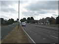
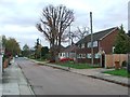
A223 North Cray Road
This section of the road, is dual carriageway leading towards the roundabout junction on the A211 and B2173.
On the left is Honeyden Road and a link road to Barton Road.
Image: © David Anstiss
Taken: 6 Aug 2010
0.12 miles
9
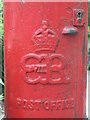
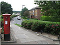
Edward VIII postbox, St James Way - royal cipher
See Image
Image: © Mike Quinn
Taken: 11 Jun 2008
0.13 miles