IMAGES TAKEN NEAR TO
Lansdowne Square, GRAVESEND, DA11 9LX
Introduction
This page details the photographs taken nearby to Lansdowne Square, DA11 9LX by members of the Geograph project.
The Geograph project started in 2005 with the aim of publishing, organising and preserving representative images for every square kilometre of Great Britain, Ireland and the Isle of Man.

There are currently over 7.5m images from over14,400 individuals and you can help contribute to the project by visiting https://www.geograph.org.uk
Image Map
Images are licensed for reuse under creativecommons.org/licenses/by-sa/2.0
Notes
- Clicking on the map will re-center to the selected point.
- The higher the marker number, the further away the image location is from the centre of the postcode.
Image Listing (80 Images Found)
Images are licensed for reuse under creativecommons.org/licenses/by-sa/2.0
Image
Details
Distance
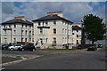
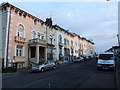
2
Lansdowne Square, Gravesend
Gravesend is a strange place. Often when wandering amongst run-down parts of the town one stumbles across buildings that clearly had some architectural pretension. No part of Gravesend is more run down at present than the area along by the river to the west of the centre, in the area known as Rosherville, and that is why these grand houses in Lansdowne Square come as a surprise.
Rosherville Gardens were laid out in 1837 in one of the disused chalk pits just west of here by Crete Hall Road, and covered an area of 17 acres. Their full title was the 'Kent Zoological and Botanical Gardens Institution’. In the Victorian period they became a favourite destination for thousands of Londoners, many travelling by paddle steamer down the River Thames to disembark at the pier built to service the gardens. By 1880 the gardens had reached the peak of their popularity and in 1901 they were closed. The presence of the gardens prompted the development of Lansdowne Square which it was hoped would attract affluent and respectable people to live in a spacious environment with views over the Thames. Four grand villas were set in the centre of a square, three of which can be seen here. However, it did not become the stylish residential area which the promoters had hoped for. In time they became run down and it is only in recent years, following the designation of a Conservation Area, that Lansdowne Square has been tidied up.
Image: © Marathon
Taken: 5 Apr 2012
0.02 miles
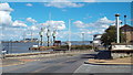
3
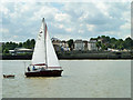
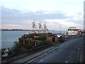
View towards Rosherville
The white buildings to the right of the yacht are in Landsdowne Square. Further right, the arched part of the waterfront is the site of Rosherville Pier, once the river station for the long-gone Rosherville Pleasure Gardens. A plaque on the waterfront partly explains the arches: "There was a ticket office and a refreshment room in a tunnel under the road." The following has more information: http://www.britishlistedbuildings.co.uk/en-508405-rosherville-quay-walls-steps-drawdock-an
Image: © Robin Webster
Taken: 30 Jun 2011
0.02 miles
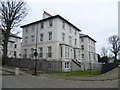
6
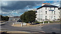
Lansdowne Square, Gravesend
Lansdowne Square in Gravesend, looking north to (and across) the River Thames.
Image: © Malc McDonald
Taken: 7 Sep 2013
0.02 miles
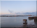
7
The Shore, Gravesend
The Shore is the name of this road in the Rosherville district of Gravesend. It is on the south bank of the River Thames.
In the background is a jetty with three cranes, while in the far distance, on the opposite bank of the river, is Tilbury power station.
Image: © Malc McDonald
Taken: 7 Sep 2013
0.03 miles
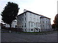
10
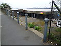
Dereliction at The Shore, Gravesend
No part of Gravesend is more run down at present than the area along by the river to the west of the centre, in the area known as Rosherville. Rosherville Gardens were laid out in 1837 in one of the disused chalk pits just west of here by Crete Hall Road, and covered an area of 17 acres. Their full title was the 'Kent Zoological and Botanical Gardens Institution’. In the Victorian period they became a favourite destination for thousands of Londoners, many travelling by paddle steamer down the River Thames to disembark at the pier built to service the gardens. By 1880 the gardens had reached the peak of their popularity and in 1901 they were closed. This scene of desolation by The Shore should hopefully be transformed at some stage by the Thames Gateway development. At present the litter strewn riverside walkway beyond the bollards leads nowhere.
Image: © Marathon
Taken: 5 Apr 2012
0.05 miles