IMAGES TAKEN NEAR TO
Farmer Close, SWANSCOMBE, DA10 1DH
Introduction
This page details the photographs taken nearby to Farmer Close, DA10 1DH by members of the Geograph project.
The Geograph project started in 2005 with the aim of publishing, organising and preserving representative images for every square kilometre of Great Britain, Ireland and the Isle of Man.

There are currently over 7.5m images from over14,400 individuals and you can help contribute to the project by visiting https://www.geograph.org.uk
Image Map
Images are licensed for reuse under creativecommons.org/licenses/by-sa/2.0
Notes
- Clicking on the map will re-center to the selected point.
- The higher the marker number, the further away the image location is from the centre of the postcode.
Image Listing (11 Images Found)
Images are licensed for reuse under creativecommons.org/licenses/by-sa/2.0
Image
Details
Distance
1
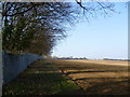
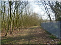
Footpath alongside Ebbsfleet Valley
Maps of this area from 30 years ago show a woodland in what is called Swanscombe Park on the other side of the metal fence. Now this has mostly been swept away and replaced by the huge Ebbsfleet Eastern Quarry. An ambitious plan has been drawn up for the future commercial and residential development of the quarry to be called Ebbsfleet Valley. It has yet to be fully started and will take between 20-25 years to develop as a whole. The white building in the distance is The Observatory. This is the base from which Land Securities, the developers of Ebbsfleet Valley, are based.
Image: © Marathon
Taken: 15 Mar 2012
0.09 miles
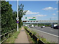
2
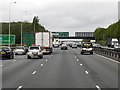
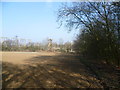
Footpath towards the A2 near Swanscombe
A footpath leads down a long flight of steps from the A2, through a belt of woodland and along the edge of a field before turning through a right angle to meet Southfleet Road. This view is from where the path emerges from the woodland and looks back towards the A2 where the gantry can be seen on the right. Maps of this area from 30 years ago show a woodland in what is called Swanscombe Park on the other side of the metal fence. Now this has mostly been swept away and replaced by the huge Ebbsfleet Eastern Quarry. An ambitious plan has been drawn up for the future commercial and residential development of the quarry to be called Ebbsfleet Valley. It has yet to be fully started and will take between 20-25 years to develop as a whole.
Image: © Marathon
Taken: 15 Mar 2012
0.15 miles
3
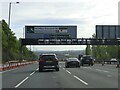
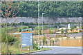
Looking towards the Northfleet West Grid Substation
A footpath leads down a long flight of steps from the A2, through a belt of woodland and along the edge of this field before turning through a right angle to meet Southfleet Road. This view is from where the path emerges from the woodland and looks towards the Northfleet West Grid Substation which was a very prominent feature alongside the A2, just before the turn-off for Ebbsfleet International when coming from London. The substation has now been demolished.
Image: © Marathon
Taken: 15 Mar 2012
0.17 miles
4
Site for future development, Castle Hill, Ebbsfleet
This is a view over a future area of development known as Castle Hill South. The sign carries the "Ebbsfleet Garden City" branding.
Image: © David Martin
Taken: 22 Jul 2018
0.19 miles
5
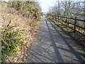
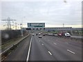
Footpath above the A2
The eight lane A2 is in a cutting below and to the right of this path. Both the A2 and the parallel path drop down ahead to the turn off for Ebbsfleet.
Image: © Marathon
Taken: 15 Mar 2012
0.20 miles
6
National Cycle Route 1 towards Gravesend
Heading east beside the A2.
Image: © JThomas
Taken: 20 Jun 2022
0.20 miles