IMAGES TAKEN NEAR TO
The Willows, NORTHWICH, CW9 6PW
Introduction
This page details the photographs taken nearby to The Willows, CW9 6PW by members of the Geograph project.
The Geograph project started in 2005 with the aim of publishing, organising and preserving representative images for every square kilometre of Great Britain, Ireland and the Isle of Man.

There are currently over 7.5m images from over14,400 individuals and you can help contribute to the project by visiting https://www.geograph.org.uk
Image Map
Images are licensed for reuse under creativecommons.org/licenses/by-sa/2.0
Notes
- Clicking on the map will re-center to the selected point.
- The higher the marker number, the further away the image location is from the centre of the postcode.
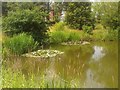
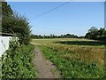
Image Listing (11 Images Found)
Images are licensed for reuse under creativecommons.org/licenses/by-sa/2.0
Image
Details
Distance
1
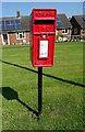
Elizabeth II postbox on Linnards Lane, Higher Wincham
Postbox No. CW9 130.
Image: © JThomas
Taken: 6 Sep 2024
0.09 miles
4
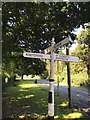
Direction Sign ? Signpost
Located on the south side of the junction of the B5391 Church Street with Linnards Lane, Higher Wincham in Wincham parish. 4 arms and pawn finial. See also http://www.flickr.com/photos/13171205@N08/8353293455
Milestone Society National ID: CH_SJ6876
Image: © R Grant
Taken: 23 Jul 2019
0.18 miles
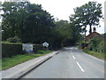
7

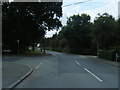
B5391, Higher Wincham, Cheshire
The stream that runs under the road forms the boundary between Vale Royal and Macclesfield districts.
Image: © michael ely
Taken: 6 Apr 2006
0.23 miles