IMAGES TAKEN NEAR TO
The Old Orchard, NORTHWICH, CW9 6LH
Introduction
This page details the photographs taken nearby to The Old Orchard, CW9 6LH by members of the Geograph project.
The Geograph project started in 2005 with the aim of publishing, organising and preserving representative images for every square kilometre of Great Britain, Ireland and the Isle of Man.

There are currently over 7.5m images from over14,400 individuals and you can help contribute to the project by visiting https://www.geograph.org.uk
Image Map
Images are licensed for reuse under creativecommons.org/licenses/by-sa/2.0
Notes
- Clicking on the map will re-center to the selected point.
- The higher the marker number, the further away the image location is from the centre of the postcode.
Image Listing (8 Images Found)
Images are licensed for reuse under creativecommons.org/licenses/by-sa/2.0
Image
Details
Distance
1
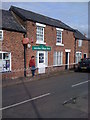
Antrobus Village Shop
The shop has become the focal point of the village. It is the place people come to for information, for tickets for events within the village and many people just drop in to buy something and for a friendly chat. (quoted from a web source)
Image: © Darrin Antrobus
Taken: 9 Apr 2009
0.03 miles
2
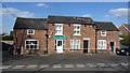
Antrobus Community Shop
A community shop with a post office.
Image: © Richard Webb
Taken: 5 Apr 2012
0.05 miles
3
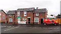
Antrobus
The village shop at Antrobus.
Image: © Peter McDermott
Taken: 29 Nov 2014
0.05 miles
5
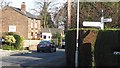
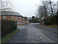
Crossroads in Antrobus
Looking down Knutsford road.
Image: © Richard Webb
Taken: 5 Apr 2012
0.06 miles
6
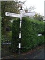
Direction Sign ? Signpost on Knutsford Road in Antrobus
Located on the southeast side of the crossroads of School Lane, Knutsford Road and Barbers Lane in Antrobus parish. 3 replacement arms, ornate spike finial and R R / D C in a shield on the pillar. It dates from the 1920’s. See also http://www.geograph.org.uk/photo/3165052.
Milestone Society National ID: CH_SJ6479
Image: © John V Nicholls
Taken: 12 Oct 2005
0.06 miles
7
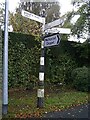
Direction Sign ? Signpost on Knutsford Road in Antrobus
Located on the southwest side of the crossroads of School Lane, Knutsford Road and Barbers Lane in Antrobus parish. 3 arms and pawn finial.
Milestone Society National ID: CH_SJ6479A
Image: © John V Nicholls
Taken: Unknown
0.07 miles
8
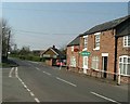
Antrobus Village centre
The Community Post Office at the corner of School Lane and Knutsford Road
Image: © Paul Baxter
Taken: 2 Apr 2005
0.15 miles