IMAGES TAKEN NEAR TO
Hough Lane, NORTHWICH, CW9 6AN
Introduction
This page details the photographs taken nearby to Hough Lane, CW9 6AN by members of the Geograph project.
The Geograph project started in 2005 with the aim of publishing, organising and preserving representative images for every square kilometre of Great Britain, Ireland and the Isle of Man.

There are currently over 7.5m images from over14,400 individuals and you can help contribute to the project by visiting https://www.geograph.org.uk
Image Map
Images are licensed for reuse under creativecommons.org/licenses/by-sa/2.0
Notes
- Clicking on the map will re-center to the selected point.
- The higher the marker number, the further away the image location is from the centre of the postcode.
Image Listing (5 Images Found)
Images are licensed for reuse under creativecommons.org/licenses/by-sa/2.0
Image
Details
Distance
1
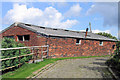
Old Byre, Houghlane Farm, Nr Barnton
Houghlane Farm shown on the OS map has been converted to a collection of private dwellings. This appears to be the last remaining original farm building
Image: © Alan Godfree
Taken: 27 Aug 2006
0.12 miles
2
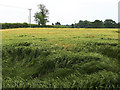
Barley field off Hough Lane
The crop appeared somewhat battered by the weather.
Image: © Stephen Craven
Taken: 23 Jun 2019
0.19 miles
3
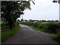
Stoneheyes Lane
Looking towards Barnton.
Image: © Stephen Craven
Taken: 23 Jun 2019
0.20 miles
5
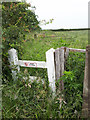
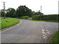
Definitely no footpath!
The warning notice seems superfluous, as two sets of fences and thick vegetation would put off most potential trespassers.
Image: © Stephen Craven
Taken: 23 Jun 2019
0.22 miles