IMAGES TAKEN NEAR TO
Pickerings, NORTHWICH, CW8 2TX
Introduction
This page details the photographs taken nearby to Pickerings, CW8 2TX by members of the Geograph project.
The Geograph project started in 2005 with the aim of publishing, organising and preserving representative images for every square kilometre of Great Britain, Ireland and the Isle of Man.

There are currently over 7.5m images from over14,400 individuals and you can help contribute to the project by visiting https://www.geograph.org.uk
Image Map
Images are licensed for reuse under creativecommons.org/licenses/by-sa/2.0
Notes
- Clicking on the map will re-center to the selected point.
- The higher the marker number, the further away the image location is from the centre of the postcode.
Image Listing (18 Images Found)
Images are licensed for reuse under creativecommons.org/licenses/by-sa/2.0
Image
Details
Distance
1
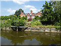
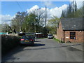
House by Pickering's Cut
On the Weaver Navigation
Image: © Chris Allen
Taken: 10 Jun 2018
0.01 miles
3
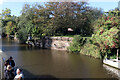
Weaver Navigation - site of Pickerings Lock
The stonework here is one side of a removed pair of side by side locks that were replaced by Dutton Locks. The view is from the steam tug Daniel Adamson.
Image: © Chris Allen
Taken: 8 Oct 2022
0.02 miles
4
Site of a swingbridge, Pickering's Wharf
On Pickering's Cut, the River Weaver. Looking downstream [locally west].
Image: © Christine Johnstone
Taken: 13 Sep 2016
0.03 miles
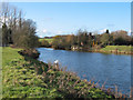
5
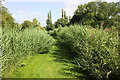
Riverside Path
Footpath through the vegetation next to the River Weaver.
Image: © Jeff Buck
Taken: 9 Jul 2014
0.04 miles
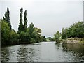
6
Pickering's Cut on the Weaver Navigation
The original course of the River Weaver flows just below to the south of this cutting. In the distance can be seen the Dutton Railway Viaduct.
Wikipedia http://en.wikipedia.org/wiki/River_Weaver
Image: © Jeff Buck
Taken: 9 Jul 2014
0.05 miles
7
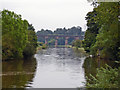
Crowton - River Weaver and Dutton Viaduct
Crowton: View up the River Weaver towards Dutton Viaduct from west of Pickering's Lock.
Image: © Mike Harris
Taken: 17 Sep 2006
0.11 miles
8
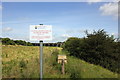
Badger Activity beside the Weaver
The sign warns horse riders to dismount and lead horses for 30 metres due to an uneven surface caused by badger activity.
Image: © Jeff Buck
Taken: 9 Jul 2014
0.11 miles
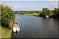
10
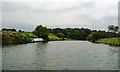
River Weaver, west of Pickering's Wharf
With a narrowboat moored on the south bank.
Image: © Christine Johnstone
Taken: 13 Sep 2016
0.13 miles