IMAGES TAKEN NEAR TO
Athelbrae Close, NORTHWICH, CW8 1EA
Introduction
This page details the photographs taken nearby to Athelbrae Close, CW8 1EA by members of the Geograph project.
The Geograph project started in 2005 with the aim of publishing, organising and preserving representative images for every square kilometre of Great Britain, Ireland and the Isle of Man.

There are currently over 7.5m images from over14,400 individuals and you can help contribute to the project by visiting https://www.geograph.org.uk
Image Map
Images are licensed for reuse under creativecommons.org/licenses/by-sa/2.0
Notes
- Clicking on the map will re-center to the selected point.
- The higher the marker number, the further away the image location is from the centre of the postcode.
Image Listing (57 Images Found)
Images are licensed for reuse under creativecommons.org/licenses/by-sa/2.0
Image
Details
Distance
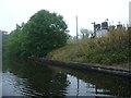
2
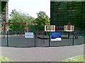
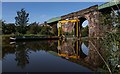
River Weaver Navigation, rail viaduct, by Hunts Lock , Northwich
Photo taken from children's playground off Yarwood Close (new estate off Spencer Street), Castle, Northwich.
Image: © john mcguire
Taken: 6 Jul 2006
0.05 miles
3
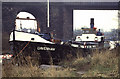
Preserved ship Davenham
Former steam powered ICI Weaver packet boat. Now diesel powered. The inverted vertical compound steam engine is at Ellesmere Port Boat Museum.
Image: © Chris Allen
Taken: 25 Jan 1992
0.07 miles
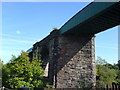
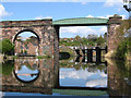
4
Railway Bridge
River Weaver below Hunts Lock
Image: © Mike Todd
Taken: 14 May 2011
0.07 miles
5
200 yard marker, east bank, Weaver Navigation
Reminding boaters that they are 200 yards north of Hunt's Lock.
Image: © Christine Johnstone
Taken: 15 Sep 2016
0.07 miles
6
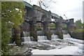
River Weaver Weir near Hunt's Locks
Listed structure dating from 1890s associated with capacity improvements at Hunt's Locks.
Image: © John M
Taken: 3 May 2014
0.09 miles
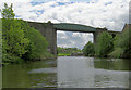
7
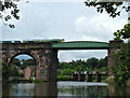
River Weaver
The River Weaver flows a curving route across Cheshire for a distance of about 50 miles from Peckforton Castle until it meets the Manchester Ship Canal at Frodsham, before the ship canal was built the Weaver ran directly into the River Mersey. Along the lower stretches from the salt producing towns of Northwich and Winsford the river was canalised to allow larger barges to use the river. In this photograph you can see the Northwich Viaduct carrying the railway across the river.
Image: © Stephen Burton
Taken: 4 Jun 2014
0.09 miles
9
Weaver Navigation
Railway viaduct over the River Weaver Navigation.
Image: © Peter McDermott
Taken: 24 Aug 2019
0.10 miles
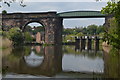
10
Northwich - Hunts Weir framed by railway viaduct
This view is taken from the recently-created cycleway along the east bank of the River Weaver.
Image: © Dave Bevis
Taken: 16 Apr 2012
0.10 miles