IMAGES TAKEN NEAR TO
Stocks Hill, WINSFORD, CW7 4EE
Introduction
This page details the photographs taken nearby to Stocks Hill, CW7 4EE by members of the Geograph project.
The Geograph project started in 2005 with the aim of publishing, organising and preserving representative images for every square kilometre of Great Britain, Ireland and the Isle of Man.

There are currently over 7.5m images from over14,400 individuals and you can help contribute to the project by visiting https://www.geograph.org.uk
Image Map
Images are licensed for reuse under creativecommons.org/licenses/by-sa/2.0
Notes
- Clicking on the map will re-center to the selected point.
- The higher the marker number, the further away the image location is from the centre of the postcode.
Image Listing (3 Images Found)
Images are licensed for reuse under creativecommons.org/licenses/by-sa/2.0
Image
Details
Distance
1
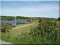
Winsford sailing club
Situated on Bottom Flash
Image: © Ian Warburton
Taken: 3 Jun 2006
0.06 miles
2
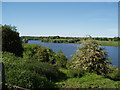
Bottom Flash, Winsford
The southerly most point of navigation of the 'Weaver Navigation', (the canalised section of the river Weaver). From here boats can access the river Mersey and the Manchester Ship Canal, although there is a height limitation under the bridges in Winsford.
Image: © Ian Warburton
Taken: 3 Jun 2006
0.10 miles
3
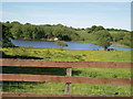
Southern end of Bottom Flash, Winsford
Taken from Weaver Dairy House. The river Weaver flows into the flash from the right.
Image: © Ian Warburton
Taken: 3 Jun 2006
0.12 miles