IMAGES TAKEN NEAR TO
Wettenhall, WINSFORD, CW7 4DQ
Introduction
This page details the photographs taken nearby to CW7 4DQ by members of the Geograph project.
The Geograph project started in 2005 with the aim of publishing, organising and preserving representative images for every square kilometre of Great Britain, Ireland and the Isle of Man.

There are currently over 7.5m images from over14,400 individuals and you can help contribute to the project by visiting https://www.geograph.org.uk
Image Map
Images are licensed for reuse under creativecommons.org/licenses/by-sa/2.0
Notes
- Clicking on the map will re-center to the selected point.
- The higher the marker number, the further away the image location is from the centre of the postcode.
Image Listing (8 Images Found)
Images are licensed for reuse under creativecommons.org/licenses/by-sa/2.0
Image
Details
Distance
1
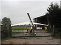
Gyrocopter (rare) and microlight (common) at Ashcroft Farm private airstrip
Image: © Dr Duncan Pepper
Taken: 14 Nov 2011
0.02 miles
2
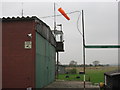
Hangar, Windsock & Control Tower at Ashcroft Farm private airstrip
Image: © Dr Duncan Pepper
Taken: 14 Nov 2011
0.04 miles
3
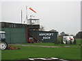
Hangar & Flying Control Tower at Ashcroft Farm private airstrip
Image: © Dr Duncan Pepper
Taken: 14 Nov 2011
0.04 miles
4
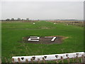
Grass runway 27 at Ashcroft Farm private airstrip
Which means take-off and landing is on a heading of 270 degrees or West in old speak.
Image: © Dr Duncan Pepper
Taken: 14 Nov 2011
0.10 miles
5
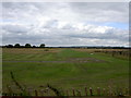
Runway at Ashcroft farm.
Quite a few aircraft out on the Bank Holiday. The nearby Ash House runs a kennels as well as having their own private runway in the same square as this.
Image: © David Quinn
Taken: 27 Aug 2007
0.11 miles