IMAGES TAKEN NEAR TO
Clay Lane, WINSFORD, CW7 2QA
Introduction
This page details the photographs taken nearby to Clay Lane, CW7 2QA by members of the Geograph project.
The Geograph project started in 2005 with the aim of publishing, organising and preserving representative images for every square kilometre of Great Britain, Ireland and the Isle of Man.

There are currently over 7.5m images from over14,400 individuals and you can help contribute to the project by visiting https://www.geograph.org.uk
Image Map
Images are licensed for reuse under creativecommons.org/licenses/by-sa/2.0
Notes
- Clicking on the map will re-center to the selected point.
- The higher the marker number, the further away the image location is from the centre of the postcode.
Image Listing (17 Images Found)
Images are licensed for reuse under creativecommons.org/licenses/by-sa/2.0
Image
Details
Distance
1

Cassia Green Lane
Looking southeast down the lane towards the hamlet of Cassia Green. Picture taken from the junction with Clay Lane.
Image: © michael ely
Taken: 27 Jun 2006
0.05 miles
2
Junction of Nova Scotia Lane and Clay Lane at Marton
Image: © Raymond Knapman
Taken: 24 Mar 2012
0.06 miles
3
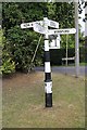
Direction Sign - Signpost in Marton
Lost finial - 4 arms; Cheshire New CCC octagonal by the UC road, in parish of Marton (Macclesfield District), junction of Nova Scotia Lane, Cassia Green and Clay Lane.
To be surveyed
Milestone Society National ID: CH_SJ6168
Image: © Milestone Society
Taken: Unknown
0.06 miles
4
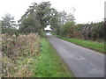
The road from Newchurch Common to Marton
Image: © Dr Duncan Pepper
Taken: 11 Nov 2011
0.14 miles
6
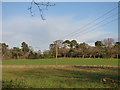
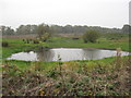
Field near Nova Scotia
With a 3-phase power line.
Image: © Stephen Craven
Taken: 28 Dec 2017
0.21 miles
7
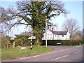
Whitegate former station plastform and road bridge
Image: © Dr Duncan Pepper
Taken: 11 Nov 2011
0.23 miles
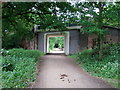
8

Whitegate Way
Approaching the former Whitegate Station (now a café with toilets and car park)
Image: © Anthony O'Neil
Taken: 27 Sep 2019
0.24 miles
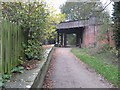
9
Whitegate Way
Approaching the new road bridge by the former Whitegate Station.
Image: © John H Darch
Taken: 12 Jun 2020
0.24 miles
10
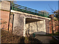
Replacement bridge at the former Whitegate Station
The bridge deck was replaced in 2014 with a modern concrete structure. At the same time the original abutments were strengthened, resulting in a narrower passage: there were originally two tracks through the bridge but there would now only be room for one, were the railway ever to be reopened.
See Image for the bridge before renewal.
Image: © Stephen Craven
Taken: 28 Dec 2017
0.24 miles