IMAGES TAKEN NEAR TO
Chapel Lane, TARPORLEY, CW6 9YF
Introduction
This page details the photographs taken nearby to Chapel Lane, CW6 9YF by members of the Geograph project.
The Geograph project started in 2005 with the aim of publishing, organising and preserving representative images for every square kilometre of Great Britain, Ireland and the Isle of Man.

There are currently over 7.5m images from over14,400 individuals and you can help contribute to the project by visiting https://www.geograph.org.uk
Image Map
Images are licensed for reuse under creativecommons.org/licenses/by-sa/2.0
Notes
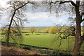
- Clicking on the map will re-center to the selected point.
- The higher the marker number, the further away the image location is from the centre of the postcode.
Image Listing (174 Images Found)
Images are licensed for reuse under creativecommons.org/licenses/by-sa/2.0
Image
Details
Distance
1
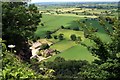
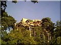
View from Beeston Castle
The Home Farm below Beeston Castle.
Image: © Jeff Buck
Taken: 25 Jun 2010
0.01 miles
2
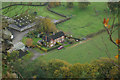
The Home Farm, Beeston
Looking down from the Beeston Castle crag to a collection of farm buildings at the foot of a precipitous drop.
Image: © Stephen McKay
Taken: 11 Nov 2017
0.01 miles
3
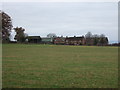
The Home Farm, Beeston
View from View from Bate's Mill Lane.
Image: © JThomas
Taken: 3 Dec 2016
0.01 miles
5
Beeston Castle near Chester
Taken from the road around the back of the Hill
Image: © chestertouristcom
Taken: 12 Jul 2005
0.05 miles
6
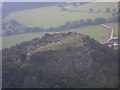
Beeston Castle from the air.
Taken from the passenger seat of a Robinson R22 helicopter.
Image: © Stephen Charles
Taken: 26 Nov 2003
0.05 miles
7
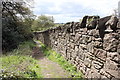
Footpath around Beeston Castle
The path through the Woodland Park skirting the perimeter of Beeston Castle, here seen at the north of the castle as it runs alongside the boundary wall.
Image: © Jeff Buck
Taken: 3 May 2016
0.06 miles
9
View from the Woodland Path at Beeston Castle
View north across the Cheshire Plain from the Woodland Park at Beeston Castle.
Image: © Jeff Buck
Taken: 3 May 2016
0.07 miles
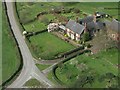
10
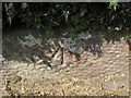
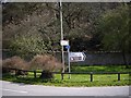
Benchmark by Home Farm, Crimes Lane, Beeston
Ordnance Survey benchmark by the entrance to Home Farm, Crimes Lane, Beeston. The farm seems to have had various names over the years having been called Castleside Farm, Rock Farm, and latterly The Home Farm. The benchmark was levelled at 60.131m above Newlyn Datum. For a wider view see: Image
Benchmark Database: https://www.bench-marks.org.uk/bm224845
Image: © John S Turner
Taken: 12 Sep 2009
0.07 miles