IMAGES TAKEN NEAR TO
Chester Road, TARPORLEY, CW6 0RR
Introduction
This page details the photographs taken nearby to Chester Road, CW6 0RR by members of the Geograph project.
The Geograph project started in 2005 with the aim of publishing, organising and preserving representative images for every square kilometre of Great Britain, Ireland and the Isle of Man.

There are currently over 7.5m images from over14,400 individuals and you can help contribute to the project by visiting https://www.geograph.org.uk
Image Map
Images are licensed for reuse under creativecommons.org/licenses/by-sa/2.0
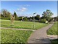
Notes
- Clicking on the map will re-center to the selected point.
- The higher the marker number, the further away the image location is from the centre of the postcode.
Image Listing (13 Images Found)
Images are licensed for reuse under creativecommons.org/licenses/by-sa/2.0
Image
Details
Distance
1
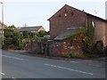
Kelsall Lock-up
The tiny lock-up stands by the side of the Chester Road on the end of a farm building
Image: © David Smith
Taken: 20 Oct 2011
0.03 miles
2
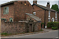
Kelsall Lock up
Lock-up: probably early-mid C19. Rock-faced buff sandstone, massive
slabs forming flat roof. Stands cl.6m in height and is semi-circular
https://britishlistedbuildings.co.uk/101130532-lock-up-on-the-end-of-the-barn-at-weldon-house-kelsall#.Yx355HbMKUk
Image: © Brian Deegan
Taken: 10 Sep 2022
0.03 miles
3
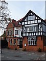
The Royal Oak, Kelsall
The stone carving above the window on the left has the inscription "Royal Oak", with a more modern label "The Oak" on the wall.
Image: © David Smith
Taken: 20 Oct 2011
0.03 miles
4
The Royal Oak, Kelsall
The Royal Oak Hotel and Restaurant (also known simply as The Oak), on Chester Road, Kelsall.
Image: © Jeff Buck
Taken: 19 Apr 2018
0.03 miles
5
Just a confirmation of changing times
Refer to the submission for the Telephone Exchange Image
Image: © Jack Hill
Taken: 14 May 2006
0.04 miles
6
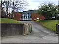
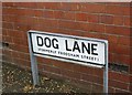
Kelsall Telephone Exchange, Dog Lane (formerly Frodsham Street)
Image: © Stephen Charles
Taken: 25 Jan 2006
0.07 miles
7
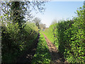
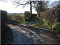
Back Lane, Kelsall
Back Lane is a narrow track to the west of Kelsall.
Image: © Jeff Buck
Taken: 19 Apr 2018
0.16 miles
8
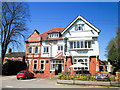
The Lord Binning, Kelsall
An inn and restaurant in the village.
Image: © David Smith
Taken: 20 Oct 2011
0.17 miles
10
Lane and Footpath Junction in Kelsall
The lane that turns left here is an access track to private property, whilst the track straight ahead provides access to outlying farmland and is also a public footpath.
Image: © John S Turner
Taken: 6 Feb 2007
0.22 miles