IMAGES TAKEN NEAR TO
Chester Road, NANTWICH, CW5 8LB
Introduction
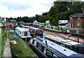
This page details the photographs taken nearby to Chester Road, CW5 8LB by members of the Geograph project.
The Geograph project started in 2005 with the aim of publishing, organising and preserving representative images for every square kilometre of Great Britain, Ireland and the Isle of Man.

There are currently over 7.5m images from over14,400 individuals and you can help contribute to the project by visiting https://www.geograph.org.uk
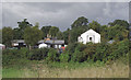
Image Map
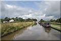
Images are licensed for reuse under creativecommons.org/licenses/by-sa/2.0
Notes
- Clicking on the map will re-center to the selected point.
- The higher the marker number, the further away the image location is from the centre of the postcode.
Image Listing (152 Images Found)
Images are licensed for reuse under creativecommons.org/licenses/by-sa/2.0
Image
Details
Distance
1
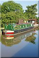
Nantwich Basin, Cheshire
This is a telephoto assisted image from the Shropshire Union Canal. The white building is by Nantwich Basin, the old Chester Canal southern terminus. Some of the old buildings at the terminus were formerly cheese warehouses.
Image: © Roger D Kidd
Taken: 27 Aug 2011
0.01 miles
2
Nantwich Basin, Shropshire Union Canal, Cheshire
The older and wider Chester Canal had its terminus here and was joined by Telford's Birmingham and Liverpool Junction Canal, eventually merging to form the Shropshire Union Canal. The arm is only two hundred metres long and is used by boat yards and a club.
Image: © Roger D Kidd
Taken: 30 Aug 2007
0.01 miles
3
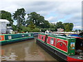
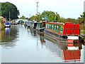
Shropshire Union Canal, Nantwich Basin
Narrow boats moored at the basin
Image: © Eirian Evans
Taken: 27 Jul 2012
0.02 miles
4
Nantwich Marina
Small marina at Basin End
Image: © Espresso Addict
Taken: 24 Aug 2007
0.03 miles
5
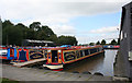
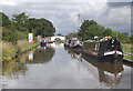
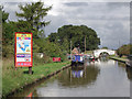
Shropshire Union Canal, Nantwich
Narrowboat 'Magpie's Nest' is moored close to the fuel and toilet pump out facilities associated with the nearby boatyard.
Image: © Stephen McKay
Taken: 8 Jul 2018
0.03 miles
6
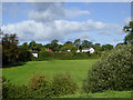
Farmland north-west of Nantwich in Cheshire
The cottage on the left is by the Chester Road (B5341). The other white buildings are by Nantwich Basin, the former terminus of the Chester Canal.
Image: © Roger D Kidd
Taken: 24 Sep 2015
0.03 miles
7
Canal north-west of Nantwich in Cheshire
This shows moorings north of Nantwich Aqueduct on the Shropshire Union Canal.
The view shows the canal, looking north-west towards Chester. Ahead is Nantwich Junction Bridge, No 92. Nantwich Junction is where Telford's canal joined the older (and wider) Chester Canal to continue the journey to Ellesmere Port. Off to the left is Nantwich Basin, the old Chester Canal terminus.
Image: © Roger Kidd
Taken: 19 Oct 2012
0.04 miles
8
Shropshire Union Canal approaching Nantwich Junction, Cheshire
Nantwich Junction is where Telford's canal joined the older (and wider) Chester Canal to continue the journey to Ellesmere Port. The white building is by Nantwich Basin, the old Chester Canal terminus.
Image: © Roger D Kidd
Taken: 27 Aug 2011
0.04 miles
9
Shropshire Union Canal approaching Nantwich Junction, Cheshire
Nantwich Junction is where Telford's canal joined the older (and wider) Chester Canal to continue the journey to Ellesmere Port. The white building is by Nantwich Basin, the old Chester Canal terminus.
Image: © Roger D Kidd
Taken: 27 Aug 2011
0.04 miles
10
Shropshire Union Canal approaching Nantwich Junction, Cheshire
Past Nantwich Junction Bridge (No 92) to the left is Nantwich Basin, the old Chester Canal southern terminus. The basin is commercially operated as Nantwich Marina.
Image: © Roger D Kidd
Taken: 27 Aug 2011
0.05 miles