IMAGES TAKEN NEAR TO
Wrenbury Frith, NANTWICH, CW5 8HN
Introduction
This page details the photographs taken nearby to Wrenbury Frith, CW5 8HN by members of the Geograph project.
The Geograph project started in 2005 with the aim of publishing, organising and preserving representative images for every square kilometre of Great Britain, Ireland and the Isle of Man.

There are currently over 7.5m images from over14,400 individuals and you can help contribute to the project by visiting https://www.geograph.org.uk
Image Map
Images are licensed for reuse under creativecommons.org/licenses/by-sa/2.0
Notes
- Clicking on the map will re-center to the selected point.
- The higher the marker number, the further away the image location is from the centre of the postcode.
Image Listing (4 Images Found)
Images are licensed for reuse under creativecommons.org/licenses/by-sa/2.0
Image
Details
Distance
2
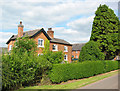
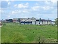
Frith Farm
Typical red-brick Victorian/Edwardian farmhouse. The name Frith is preserved in a few farms and the civil parish of Wrenbury-cum-Frith, but there is no evidence of a settlement. See also Image
Image: © Espresso Addict
Taken: 23 Jun 2006
0.04 miles
3
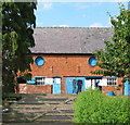
Washing day
These red-brick outbuildings at Frith Farm (Image), showing circular windows, ventilation holes and a slate-tiled roof, are typical of the locality
Image: © Espresso Addict
Taken: 23 Jun 2006
0.10 miles
4
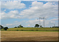
Iron trees
A major electricity pylon runs diagonally across the gridsquare. View from the road, immediately west of Frith Farm, facing north
Image: © Espresso Addict
Taken: 23 Jun 2006
0.16 miles