IMAGES TAKEN NEAR TO
Chester Road, NANTWICH, CW5 8FT
Introduction
This page details the photographs taken nearby to Chester Road, CW5 8FT by members of the Geograph project.
The Geograph project started in 2005 with the aim of publishing, organising and preserving representative images for every square kilometre of Great Britain, Ireland and the Isle of Man.

There are currently over 7.5m images from over14,400 individuals and you can help contribute to the project by visiting https://www.geograph.org.uk
Image Map
Images are licensed for reuse under creativecommons.org/licenses/by-sa/2.0
Notes
- Clicking on the map will re-center to the selected point.
- The higher the marker number, the further away the image location is from the centre of the postcode.
Image Listing (87 Images Found)
Images are licensed for reuse under creativecommons.org/licenses/by-sa/2.0
Image
Details
Distance
1
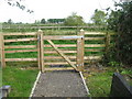
Gate to nowhere
In the churchyard of St Mary's Acton - the gate opens, but access beyond to Church Farm is prevented by another layer of fixed fencing.
Image: © M J Richardson
Taken: 21 Sep 2013
0.02 miles
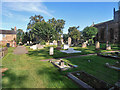
2
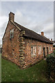
Almshouses, Church Grounds, Acton
The centre of Acton village has been designated a conservation area and contains several historic buildings. Apart from the church, the oldest buildings are a pair of grade-II-listed red-brick almshouses in the churchyard which were built by Sir Roger Wilbraham in 1613.
Acton >> https://en.wikipedia.org/wiki/Acton,_Cheshire
Almshouses >> https://en.wikipedia.org/wiki/Acton,_Cheshire
Image: © Brian Deegan
Taken: 18 Nov 2017
0.03 miles
3
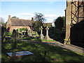
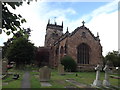
St Mary's churchyard, Acton
Looking across the churchyard of St Mary's towards the 17th century, Grade II listed almshouses. On the tower buttress at the right of the photo there is a bench mark - Image
Image: © John S Turner
Taken: 16 Oct 2009
0.03 miles
4
Almshouses in Acton churchyard
An early 17-C Grade 2 listed building.
Image: © M J Richardson
Taken: 21 Sep 2013
0.03 miles
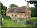
5
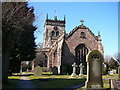
St Mary's Church, Acton
This fine church dominates the village of Acton. Its tower is said to be the oldest in Cheshire and dates from 1180 however much of it was rebuilt after a storm in March 1757. The church was used as a headquarters for Royalist Troops during the Civil War battle on or about the 25th of January 1644. Nearby at Acton Bridge over the Shropshire Union canal is a display board describing the events of the battle.
Image: © Colin Park
Taken: 7 Mar 2010
0.05 miles
6
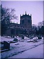
Acton - St. Mary's Church
Pre-dates St. Mary's Nantwich by 100 years
Image: © Mike Grose
Taken: 12 Mar 2006
0.05 miles
7
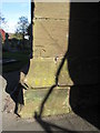
1GL Bench mark on Acton St Mary's church tower?
This bench mark is on the south west face of the buttress at the north west corner of St Mary's church. The Grade I listing of the church http://www.imagesofengland.org.uk/details/default.aspx?id=56928 indicates that the tower dates to the 13th century and, although it collapsed and was rebuilt around 1757, the lower part is still original. However, like most old churches maintenance and changes are constantly taking place. The surveyors schedule from the Ordnance Survey's First Geodetic Levelling 1851-1858 on the line between Newcastle under Lyme and Chester, states that the CM is on the 'South-west angle of Acton Church tower'. This mark is on the north west angle of the church, albeit facing south west, so it now seems unlikely that this bench mark could be the one from the first survey. See also Image
Image: © John S Turner
Taken: 16 Oct 2009
0.05 miles
8
St Mary's church, Acton
Looking West from the A534, Chester Road
Image: © Garry Lavender-Rimmer
Taken: 31 Aug 2016
0.05 miles
10
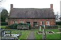
Almshouses in St Mary's Churchyard, Acton
Pair of grade-II-listed almshouses to the north of St Mary's Church, dating from the early 17th century. Now disused, the windows are bricked up. For more information, see: http://www.imagesofengland.org.uk/details/default.aspx?id=56929
Image: © Espresso Addict
Taken: 22 Feb 2008
0.05 miles