IMAGES TAKEN NEAR TO
Wrenbury Road, NANTWICH, CW5 8DQ
Introduction
This page details the photographs taken nearby to Wrenbury Road, CW5 8DQ by members of the Geograph project.
The Geograph project started in 2005 with the aim of publishing, organising and preserving representative images for every square kilometre of Great Britain, Ireland and the Isle of Man.

There are currently over 7.5m images from over14,400 individuals and you can help contribute to the project by visiting https://www.geograph.org.uk
Image Map
Images are licensed for reuse under creativecommons.org/licenses/by-sa/2.0
Notes
- Clicking on the map will re-center to the selected point.
- The higher the marker number, the further away the image location is from the centre of the postcode.
Image Listing (16 Images Found)
Images are licensed for reuse under creativecommons.org/licenses/by-sa/2.0
Image
Details
Distance
1
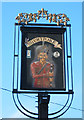
The Bhurtpore Inn sign
The Bhurtpore Inn in Aston dates from around 1720, and was so named in 1826 to commemorate the Siege of Bhurtpore at which local landowner Sir Stapleton Cotton (later Viscount Combermere) was Commander-in-Chief. A former pub in nearby Wrenbury was named Salamanca Hotel after another victory (see Image). See http://www.bhurtpore.co.uk/history.htm
Image: © Espresso Addict
Taken: 14 Feb 2007
0.06 miles
2
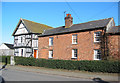
Aston House Farm
This grade-II-listed, black-and-white timbered farmhouse dates from 1662, with 19th century red-brick additions. One of several black-and-white buildings in and around the village of Aston. It stands opposite The Bhurtpore public house (in Image), and the left side of the building just slips into Image See http://www.imagesofengland.org.uk/search/details.aspx?id=422248
Image: © Espresso Addict
Taken: 14 Feb 2007
0.06 miles
3
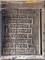
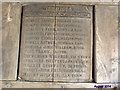
Inside Lych gate
Plaque inside cemetery lych gate. This is on the Right hand side as you enter.
Image: © Garry Lavender-Rimmer
Taken: 9 Aug 2014
0.10 miles
4
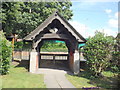
St Andrew's Lych gate
St. Andrew's lych gate seen from inside the cemetery. Note in the background part of Aston Mill can be seen (RHS).
Image: © Garry Lavender-Rimmer
Taken: 9 Aug 2014
0.10 miles
5
Great War memorial plaque
List of local men killed during the 1914 - 1918 war.
Image: © Garry Lavender-Rimmer
Taken: 9 Aug 2014
0.10 miles
6
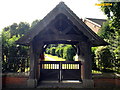
Cemetery Gate
Lych gate at St Andrew's Methodist cemetery in Aston.
Image: © Garry Lavender-Rimmer
Taken: 9 Aug 2014
0.10 miles
7
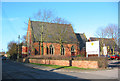
St Andrew's Methodist Church, Aston
This red-brick Methodist church stands next to the busy Aston Mill (right; Image). A former Wesleyan Chapel dating from 1866, an inscription over the entrance reads 'Wesleyan Chapel Erected MDCCCLXVI'
Image: © Espresso Addict
Taken: 14 Feb 2007
0.10 miles
8
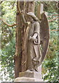
Headstone
Headstone on Huntbach family grave in St. Andrew's cemetery.
Image: © Garry Lavender-Rimmer
Taken: 21 Jul 2014
0.11 miles
9
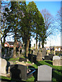
Aston Cemetery
This peaceful burial ground is set around 50m back from Wrenbury Road, accessed via a lych gate; it backs onto pasture on all four sides. Image (left) & Image (right), in Image, are visible in the distance
Image: © Espresso Addict
Taken: 14 Feb 2007
0.13 miles
10
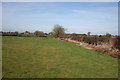
Pasture near Aston
Gently sloping cattle pasture with occasional deciduous trees in the hedgerows immediately north of the village of Aston. The River Weaver runs in the dip (line of trees, centre left). The ochre field (right) is the arable field shown in Image Woodcotthill Farm is visible (left; in Image). View from the South Cheshire Way
Image: © Espresso Addict
Taken: 16 Mar 2009
0.14 miles