IMAGES TAKEN NEAR TO
Dodds Green Lane, NANTWICH, CW5 8DP
Introduction
This page details the photographs taken nearby to Dodds Green Lane, CW5 8DP by members of the Geograph project.
The Geograph project started in 2005 with the aim of publishing, organising and preserving representative images for every square kilometre of Great Britain, Ireland and the Isle of Man.

There are currently over 7.5m images from over14,400 individuals and you can help contribute to the project by visiting https://www.geograph.org.uk
Image Map
Images are licensed for reuse under creativecommons.org/licenses/by-sa/2.0
Notes
- Clicking on the map will re-center to the selected point.
- The higher the marker number, the further away the image location is from the centre of the postcode.
Image Listing (1 Images Found)
Images are licensed for reuse under creativecommons.org/licenses/by-sa/2.0
Image
Details
Distance
1
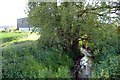
Sales Brook at Salesbrook Farm, Newhall
Sales Brook runs into the larger Barnett Brook a little to the south-east, the latter soon running into the infant River Weaver. The stream banks provide a miniature eco-system amidst the intensively cultivated land - here there are wheat fields to either side.
Image: © Mike Harris
Taken: 7 Jun 2006
0.21 miles