IMAGES TAKEN NEAR TO
Arden Close, NANTWICH, CW5 7TN
Introduction
This page details the photographs taken nearby to Arden Close, CW5 7TN by members of the Geograph project.
The Geograph project started in 2005 with the aim of publishing, organising and preserving representative images for every square kilometre of Great Britain, Ireland and the Isle of Man.

There are currently over 7.5m images from over14,400 individuals and you can help contribute to the project by visiting https://www.geograph.org.uk
Image Map
Images are licensed for reuse under creativecommons.org/licenses/by-sa/2.0
Notes
- Clicking on the map will re-center to the selected point.
- The higher the marker number, the further away the image location is from the centre of the postcode.
Image Listing (8 Images Found)
Images are licensed for reuse under creativecommons.org/licenses/by-sa/2.0
Image
Details
Distance
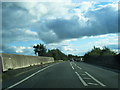
1
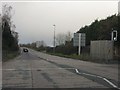
Nantwich bypass at Cheerbrook Road
The pedestrian crossing marks the former course of the Nantwich-Newcastle road.
Image: © Peter Whatley
Taken: 7 Dec 2011
0.19 miles
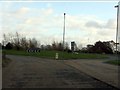
4
Nantwich bypass crosses the railway line
Image: © Peter Whatley
Taken: 7 Dec 2011
0.22 miles
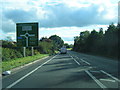
5
A51 crosses the Crewe to Shrewsbury railway line
Image: © Colin Pyle
Taken: 6 Oct 2012
0.22 miles
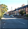
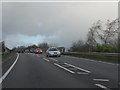
7
Cheerbrook roundabout from Newcastle Road
Image: © Peter Whatley
Taken: 7 Dec 2011
0.24 miles
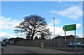
8
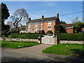
Cheer Brook Farmhouse
The building was used as an auxiliary hospital during the First World War.
Image: © John M
Taken: 9 Apr 2017
0.24 miles