IMAGES TAKEN NEAR TO
Audlem Road, NANTWICH, CW5 7QJ
Introduction
This page details the photographs taken nearby to Audlem Road, CW5 7QJ by members of the Geograph project.
The Geograph project started in 2005 with the aim of publishing, organising and preserving representative images for every square kilometre of Great Britain, Ireland and the Isle of Man.

There are currently over 7.5m images from over14,400 individuals and you can help contribute to the project by visiting https://www.geograph.org.uk
Image Map
Images are licensed for reuse under creativecommons.org/licenses/by-sa/2.0
Notes
- Clicking on the map will re-center to the selected point.
- The higher the marker number, the further away the image location is from the centre of the postcode.
Image Listing (26 Images Found)
Images are licensed for reuse under creativecommons.org/licenses/by-sa/2.0
Image
Details
Distance
1
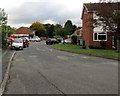
West along Mill Way, Nantwich
For motor vehicles, this is a dead-end road. Walkers and cyclists can reach the A529 Audlem Road ahead.
Image: © Jaggery
Taken: 13 Oct 2016
0.02 miles
2
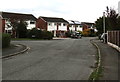
Junction of Mill Way and Bishops Wood, Nantwich
Mill Way on the left diverges from Bishops Wood.
Image: © Jaggery
Taken: 13 Oct 2016
0.04 miles
3
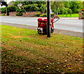
Royal Mail delivery trolley, Audlem Road, Nantwich
While a postman delivers mail to nearby houses, the locked trolley containing the rest of the mail is padlocked to an Audlem Road lamppost. Long gone is the era when a postman or postwoman had to carry a heavy bag filled with all the mail of a delivery round.
Image: © Jaggery
Taken: 13 Oct 2016
0.04 miles
4
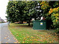
United Utilities Sewage Pumping Station, Audlem Road, Nantwich
Surrounded by autumn colours in mid October 2016.
The United Utilities identifier on the green cabinet is 16033 Bishops Wood.
The notices and warnings on the cabinet include Caution Deep Water, Caution Hazardous Areas and No Smoking.
Image: © Jaggery
Taken: 13 Oct 2016
0.04 miles
5
Bend in Bishops Wood, Nantwich
On the north side of the A529, the course of the road named
Bishops Wood bends towards the Mill Way junction, out of shot.
Image: © Jaggery
Taken: 13 Oct 2016
0.05 miles
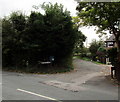
6
Junction of the A529 and Bishops Wood, Nantwich
Looking north along Bishops Wood, the road which marks the transition
from the A529 Audlem Road to the left and the A529 Broad Lane to the right.
Image: © Jaggery
Taken: 13 Oct 2016
0.05 miles
7
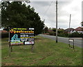
Nantwich Spooktacula advert on a south Nantwich corner
Viewed on October 13th 2016. The board on the corner of Bishops Wood and Broad Lane advertises the Nantwich Spooktacula to be held on Nantwich Show Ground on Saturday October 29th 2016. Attractions shown are fireworks, bonfire, funfair. Gates open at 5pm. Sponsored by Frizells Haulage and Plant Hire Ltd.
Image: © Jaggery
Taken: 13 Oct 2016
0.05 miles
8
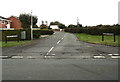
Batherton Lane, Nantwich
Dead-end lane viewed across the A529 Audlem Road.
Image: © Jaggery
Taken: 13 Oct 2016
0.06 miles
9
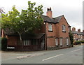
Tollgate House, Audlem Road, Nantwich
Former turnpike tollhouse on the corner of Audlem Road and Batherton Lane in the south of Nantwich.
Image: © Jaggery
Taken: 13 Oct 2016
0.06 miles
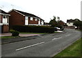
10
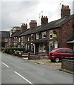
Row of houses on the west side of Audlem Road, Nantwich
Looking towards a former turnpike tollhouse http://www.geograph.org.uk/photo/5153924 at the left edge of the photo.
Image: © Jaggery
Taken: 13 Oct 2016
0.07 miles