IMAGES TAKEN NEAR TO
Bridgemere Lane, NANTWICH, CW5 7PN
Introduction
This page details the photographs taken nearby to Bridgemere Lane, CW5 7PN by members of the Geograph project.
The Geograph project started in 2005 with the aim of publishing, organising and preserving representative images for every square kilometre of Great Britain, Ireland and the Isle of Man.

There are currently over 7.5m images from over14,400 individuals and you can help contribute to the project by visiting https://www.geograph.org.uk
Image Map (Loading...)


Getting Data...Please wait
Leaflet Map data © OpenStreetMap
Images are licensed for reuse under creativecommons.org/licenses/by-sa/2.0
Notes
- Clicking on the map will re-center to the selected point.
- The higher the marker number, the further away the image location is from the centre of the postcode.
Image Listing (2 Images Found)
Images are licensed for reuse under creativecommons.org/licenses/by-sa/2.0
Image
Details
Distance
1
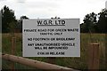
Green Waste Centre
A newly created track leads across the fields here; unfortunately the official right-of-way I was trying to follow was utterly impassable so I'm afraid I had little option but to disobey this sign. Can't say I'm exactly racked with guilt.
Image: © Dave Dunford
Taken: 16 Sep 2009
0.09 miles
2
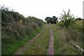
South Cheshire Way
After major difficulties with rights-of-way in the squares to the south it was a relief to get back onto a well-marked footpath.
Image: © Dave Dunford
Taken: 16 Sep 2009
0.17 miles