IMAGES TAKEN NEAR TO
Crewe Road, NANTWICH, CW5 7PE
Introduction
This page details the photographs taken nearby to Crewe Road, CW5 7PE by members of the Geograph project.
The Geograph project started in 2005 with the aim of publishing, organising and preserving representative images for every square kilometre of Great Britain, Ireland and the Isle of Man.

There are currently over 7.5m images from over14,400 individuals and you can help contribute to the project by visiting https://www.geograph.org.uk
Image Map
Images are licensed for reuse under creativecommons.org/licenses/by-sa/2.0
Notes
- Clicking on the map will re-center to the selected point.
- The higher the marker number, the further away the image location is from the centre of the postcode.
Image Listing (5 Images Found)
Images are licensed for reuse under creativecommons.org/licenses/by-sa/2.0
Image
Details
Distance
1
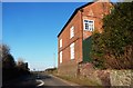
Methodist Church
Methodist church converted to residential building.
Image: © Andy and Hilary
Taken: 16 Apr 2005
0.17 miles
2
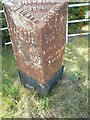
Old Milepost by the A529 at Oakes Corner, Hatherton
Cast iron post by the A529, in parish of Hatherton (Crewe and Nantwich District), Oakes Corner, on the verge in front of metal railings, on West side of road. Cast iron CCC1896, erected by the County Council in the 19th century.
Inscription reads:-
: NANTWICH / 4 MILES : : CHESHIRE / 1896 / COUNTY COUNCIL : : AUDLEM / 2½ MILES / ADDERLEY 5 / MARKET DRAYTON / 9 MILES :
Maker:-
: W H SMITH & CO / MAKERS / WHITCHURCH :
Milestone Society National ID: CH_NWMD04
Image: © J Higgins
Taken: 2 Apr 2013
0.20 miles
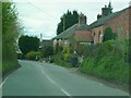
3
Crossroads at Hatherton
Looking across into Park Lane, in the evening light.
Image: © Christopher Hilton
Taken: 2 Jun 2016
0.21 miles
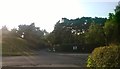
4
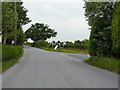
Junction of Park Lane with Crewe Road
Image: © Alexander P Kapp
Taken: 27 Jul 2011
0.21 miles