IMAGES TAKEN NEAR TO
Wrinehill Road, NANTWICH, CW5 7NS
Introduction
This page details the photographs taken nearby to Wrinehill Road, CW5 7NS by members of the Geograph project.
The Geograph project started in 2005 with the aim of publishing, organising and preserving representative images for every square kilometre of Great Britain, Ireland and the Isle of Man.

There are currently over 7.5m images from over14,400 individuals and you can help contribute to the project by visiting https://www.geograph.org.uk
Image Map
Images are licensed for reuse under creativecommons.org/licenses/by-sa/2.0
Notes
- Clicking on the map will re-center to the selected point.
- The higher the marker number, the further away the image location is from the centre of the postcode.
Image Listing (6 Images Found)
Images are licensed for reuse under creativecommons.org/licenses/by-sa/2.0
Image
Details
Distance
1
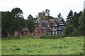
Lea Hall
Lea Hall is an impressive 16th-century timber-framed and gabled building with later additions. It is Grade II* listed by English Heritage and, most unusually, appears to have escaped the notice of the antiquarian Sir Nikolaus Pevsner in his comprehensive and authoritative Buildings of England series. See http://www.imagesofengland.org.uk/details/default.aspx?id=57123 for more details.
Image: © Dave Dunford
Taken: 16 Sep 2009
0.01 miles
2
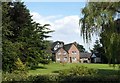
Lea Hall
Rear of Lea Hall seen from the South Cheshire Way long distance footpath.
Image: © Steve Lewin
Taken: 9 Aug 2007
0.04 miles
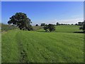
4
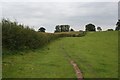
Approaching Lea Hall Farm
On the footpath (South Cheshire Way) from Lea Forge.
Image: © Dave Dunford
Taken: 16 Sep 2009
0.22 miles
6
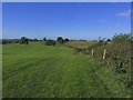
On the S Cheshire Way, W of Lea Hall, Lea
Image: © Colin Park
Taken: 26 Sep 2015
0.23 miles