IMAGES TAKEN NEAR TO
Blakenhall, NANTWICH, CW5 7NR
Introduction
This page details the photographs taken nearby to CW5 7NR by members of the Geograph project.
The Geograph project started in 2005 with the aim of publishing, organising and preserving representative images for every square kilometre of Great Britain, Ireland and the Isle of Man.

There are currently over 7.5m images from over14,400 individuals and you can help contribute to the project by visiting https://www.geograph.org.uk
Image Map
Images are licensed for reuse under creativecommons.org/licenses/by-sa/2.0
Notes
- Clicking on the map will re-center to the selected point.
- The higher the marker number, the further away the image location is from the centre of the postcode.
Image Listing (4 Images Found)
Images are licensed for reuse under creativecommons.org/licenses/by-sa/2.0
Image
Details
Distance
1
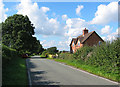
Gonsley Cottages and Den Lane
Den Lane is a busy, relatively broad, single-track lane. This pair of brick semi-detached houses stand in the midst of farmland near Gonsley Green Farm, and are typical of much 20th century rural housing in this area of Cheshire
Image: © Espresso Addict
Taken: 24 Sep 2006
0.03 miles
2
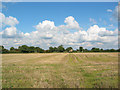
View towards Gonsley Green Farm
View from Den Lane across large recently harvested field towards Gonsley Green Farm. The farm itself lies on the boundary with Image
Image: © Espresso Addict
Taken: 24 Sep 2006
0.06 miles
3
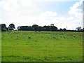
View towards Blakenhall Moss
View across pastureland towards the small broad-leaved wood, Blakenhall Moss. View from Den Lane
Image: © Espresso Addict
Taken: 24 Sep 2006
0.22 miles
4
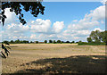
View towards Gonsley Green Farm
View across recently harvested grain field, from Den Lane. The farm in the distance is Gonsley Green Farm, on the boundary with Image The trees on right of frame are on a field boundary, one of a set of small fields just west of the T-junction with Mill Lane
Image: © Espresso Addict
Taken: 24 Sep 2006
0.23 miles