IMAGES TAKEN NEAR TO
Back Lane, NANTWICH, CW5 7NQ
Introduction
This page details the photographs taken nearby to Back Lane, CW5 7NQ by members of the Geograph project.
The Geograph project started in 2005 with the aim of publishing, organising and preserving representative images for every square kilometre of Great Britain, Ireland and the Isle of Man.

There are currently over 7.5m images from over14,400 individuals and you can help contribute to the project by visiting https://www.geograph.org.uk
Image Map
Images are licensed for reuse under creativecommons.org/licenses/by-sa/2.0
Notes
- Clicking on the map will re-center to the selected point.
- The higher the marker number, the further away the image location is from the centre of the postcode.
Image Listing (4 Images Found)
Images are licensed for reuse under creativecommons.org/licenses/by-sa/2.0
Image
Details
Distance
3
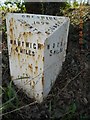
Old Milepost by the A51, London Road, Walgherton
Cast iron post by the A51, in parish of Walgherton (Crewe and Nantwich District), Walgherton, on grass verge, on South West side of road. Cast iron CCC1898, erected by the County Council in the 19th century.
Inscription reads:-
: NANTWICH / 4 MILES : : CHESHIRE / 1898 / COUNTY COUNCIL : : WOORE / 5 MILES :
Maker:-
: W H SMITH & CO / MAKERS / WHITCHURCH :
Milestone Society National ID: CH_NWWO04
Image: © J Higgins
Taken: 1 Mar 2004
0.22 miles
4
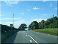
A51 London Road nears Walgherton boundary
Image: © Colin Pyle
Taken: 20 Aug 2020
0.25 miles