IMAGES TAKEN NEAR TO
Mill Lane, NANTWICH, CW5 7NN
Introduction
This page details the photographs taken nearby to Mill Lane, CW5 7NN by members of the Geograph project.
The Geograph project started in 2005 with the aim of publishing, organising and preserving representative images for every square kilometre of Great Britain, Ireland and the Isle of Man.

There are currently over 7.5m images from over14,400 individuals and you can help contribute to the project by visiting https://www.geograph.org.uk
Image Map
Images are licensed for reuse under creativecommons.org/licenses/by-sa/2.0
Notes
- Clicking on the map will re-center to the selected point.
- The higher the marker number, the further away the image location is from the centre of the postcode.
Image Listing (7 Images Found)
Images are licensed for reuse under creativecommons.org/licenses/by-sa/2.0
Image
Details
Distance
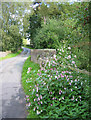
1
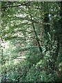
Mill Covert
A narrow strip of broad-leaved woodland runs beside Forge Brook. The orchid-like flowers in the foreground may be escapees from an adjacent garden
Image: © Espresso Addict
Taken: 24 Sep 2006
0.02 miles
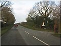
2
Doddington Mill
Bridge over Forge Brook at Doddington Mill
Image: © P Gaskell
Taken: Unknown
0.05 miles
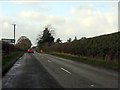
3
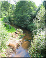
Forge Brook and Mill Covert
A pleasant small brook lined with willows, within earshot of the A51. View from bridge on Mill Lane
Image: © Espresso Addict
Taken: 24 Sep 2006
0.06 miles
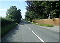
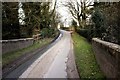
4
Bridge over Forge Brook
Mill Lane, showing bridge over Forge Brook at Mill Covert. The orchid-like flowers in the foreground may have been an escapee from a neighbouring garden
Image: © Espresso Addict
Taken: 24 Sep 2006
0.06 miles