IMAGES TAKEN NEAR TO
Bridge Street, NANTWICH, CW5 7NB
Introduction
This page details the photographs taken nearby to Bridge Street, CW5 7NB by members of the Geograph project.
The Geograph project started in 2005 with the aim of publishing, organising and preserving representative images for every square kilometre of Great Britain, Ireland and the Isle of Man.

There are currently over 7.5m images from over14,400 individuals and you can help contribute to the project by visiting https://www.geograph.org.uk
Image Map
Images are licensed for reuse under creativecommons.org/licenses/by-sa/2.0
Notes
- Clicking on the map will re-center to the selected point.
- The higher the marker number, the further away the image location is from the centre of the postcode.
Image Listing (60 Images Found)
Images are licensed for reuse under creativecommons.org/licenses/by-sa/2.0
Image
Details
Distance
1
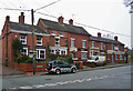
The 'Red Lion', Wybunbury, Cheshire
The interesting village of Wybunbury ('Wimbury') is fortunate in having two public houses: the 'Red Lion', shown here, has the very fine Thwaites ales (brewed in the adjacent County of Lancashire), while the 'Swan' (seen here in the distance on the other side of the road) has Robinson's Stockport ales.
Image: © Dr Neil Clifton
Taken: 20 Jul 2008
0.02 miles
2
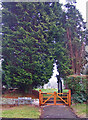
St Chad's Cemetery entrance
This large cemetery lies to the south of Wrinehill Road, while St Chad's Church stood to the north. The church itself has been demolished, having become unsafe due to subsidence. The tower still stands. The small plaque on the left hand gate post is inscribed: 'Gates donated in memory of Wybunbury Methodist Chapel, 1864 to 2008'.
Image: © Richard Dorrell
Taken: 22 Jan 2011
0.02 miles
3

Wybunbury Garage
Located in Bridge Street. Traditional garage offering fuel, servicing and used car sales.
Image: © Richard Dorrell
Taken: 22 Jan 2011
0.02 miles
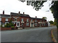
4
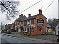
The Red Lion, Wybunbury - closed
The pub stands prominently opposite the historic St Chad's Church tower, but its location, and live Sky Sports TV wasn't enough to save it from closure. The building has been stripped of its contents, and is securely boarded up.
Update (February 2012) I have been contacted by Peter Knowles of Nextep Inns Limited who tells me that the Red Lion will re-open last week in March 2012, following a major refurbishment.
Image: © Richard Dorrell
Taken: 22 Jan 2011
0.03 miles
5
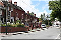
Houses and pub, Main Road, Wybunbury
The photographer is standing in Wrinehill Road, outside the gates to St Chad's Cemetery. The pub, which occupies the right hand end of the buildings pictured, is The Red Lion, recently closed, and currently boarded up.
Update (February 2012) I have been contacted by Peter Knowles of Nextep Inns Limited who tells me that the Red Lion will re-open last week in March 2012, following a major refurbishment.
Image: © Richard Dorrell
Taken: 22 Jan 2011
0.04 miles
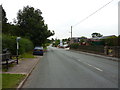
7
Old Direction Sign - Signpost by the B5071, Main Road, Wybunbury
Pawn finial - 4 arms; Cheshire CCC octagonal by the B5071, in parish of Wybunbury (Crewe and Nantwich District), junction of Main Road with Wrinehill Road, South of church.
Surveyed
Milestone Society National ID: CH_SJ7049
Image: © Milestone Society
Taken: Unknown
0.04 miles
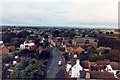
9
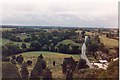
View from Wybunbury Tower looking south
Looking down Bridge Street towards the school
Image: © Mike Grose
Taken: Unknown
0.05 miles
10
View from Wybunbury Tower looking west
Just visible on horizon are Bickerton/Beeston Hills
Image: © Mike Grose
Taken: Unknown
0.05 miles