IMAGES TAKEN NEAR TO
Sandy Lane, NANTWICH, CW5 7LQ
Introduction
This page details the photographs taken nearby to Sandy Lane, CW5 7LQ by members of the Geograph project.
The Geograph project started in 2005 with the aim of publishing, organising and preserving representative images for every square kilometre of Great Britain, Ireland and the Isle of Man.

There are currently over 7.5m images from over14,400 individuals and you can help contribute to the project by visiting https://www.geograph.org.uk
Image Map
Images are licensed for reuse under creativecommons.org/licenses/by-sa/2.0
Notes
- Clicking on the map will re-center to the selected point.
- The higher the marker number, the further away the image location is from the centre of the postcode.
Image Listing (4 Images Found)
Images are licensed for reuse under creativecommons.org/licenses/by-sa/2.0
Image
Details
Distance
2

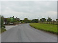
Walgherton: Dagfield's Craft Centre car park
Image: © Michael Garlick
Taken: 2 May 2024
0.18 miles
3
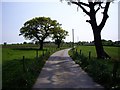
Footpath along farm road from Oat Eddish Farm
I was glad to get onto this path, I did not like the cows in the field next to it
Image: © Ian Bottomley
Taken: 28 Apr 2007
0.21 miles
4
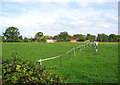
Paddocks by the B5071
One of a series of paddocks to the east of the B5071, most of which contain only a single horse
Image: © Espresso Addict
Taken: 17 Sep 2006
0.24 miles