IMAGES TAKEN NEAR TO
Stock Lane, NANTWICH, CW5 7HF
Introduction
This page details the photographs taken nearby to Stock Lane, CW5 7HF by members of the Geograph project.
The Geograph project started in 2005 with the aim of publishing, organising and preserving representative images for every square kilometre of Great Britain, Ireland and the Isle of Man.

There are currently over 7.5m images from over14,400 individuals and you can help contribute to the project by visiting https://www.geograph.org.uk
Image Map
Images are licensed for reuse under creativecommons.org/licenses/by-sa/2.0
Notes
- Clicking on the map will re-center to the selected point.
- The higher the marker number, the further away the image location is from the centre of the postcode.
Image Listing (3 Images Found)
Images are licensed for reuse under creativecommons.org/licenses/by-sa/2.0
Image
Details
Distance
1
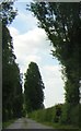
Driveway to Wybunbury Grange
The double line of poplars on the long driveway from Stock Lane to Wybunbury Grange are visible for a mile or so around on this level terrain.
Image: © Christopher Hilton
Taken: 3 Jun 2016
0.11 miles
3
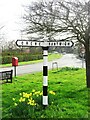
Direction Sign ? Signpost on the B5071 in Wybunbury parish
Located on a grass triangle in the centre of the junction of the B5071 Stock Lane and Wybunbury Lane in Wybunbury parish. 2 arms and pawn finial.
Milestone Society National ID: CH_SJ6950
Image: © T Jenkinson
Taken: 22 Mar 2012
0.15 miles