IMAGES TAKEN NEAR TO
Stock Lane, NANTWICH, CW5 7HA
Introduction
This page details the photographs taken nearby to Stock Lane, CW5 7HA by members of the Geograph project.
The Geograph project started in 2005 with the aim of publishing, organising and preserving representative images for every square kilometre of Great Britain, Ireland and the Isle of Man.

There are currently over 7.5m images from over14,400 individuals and you can help contribute to the project by visiting https://www.geograph.org.uk
Image Map
Images are licensed for reuse under creativecommons.org/licenses/by-sa/2.0
Notes
- Clicking on the map will re-center to the selected point.
- The higher the marker number, the further away the image location is from the centre of the postcode.
Image Listing (6 Images Found)
Images are licensed for reuse under creativecommons.org/licenses/by-sa/2.0
Image
Details
Distance
1
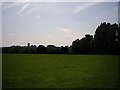
Fields Near Cockshades Farm Looking towards the church
Image: © Ian Bottomley
Taken: 9 Jun 2007
0.05 miles
2
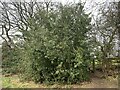
Holly tree by footpath near Wybunbury
The footpath and stile are almost hidden on the right hand side of the tree. The footpath is designated Wybunbury FP5.
Image: © Jonathan Hutchins
Taken: 17 Feb 2019
0.14 miles
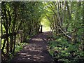
5
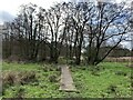
Boardwalk on east edge of Wybunbury Moss
Image: © Jonathan Hutchins
Taken: 16 Feb 2019
0.18 miles
6
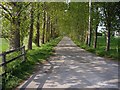
Lane by Cockshades Farm
This lane is at the end of a footpath between Wynbunbury and Shavington, it leads onto Stock Lane
Image: © Ian Bottomley
Taken: 28 Apr 2007
0.19 miles