IMAGES TAKEN NEAR TO
Wellington Road, NANTWICH, CW5 7ED
Introduction
This page details the photographs taken nearby to Wellington Road, CW5 7ED by members of the Geograph project.
The Geograph project started in 2005 with the aim of publishing, organising and preserving representative images for every square kilometre of Great Britain, Ireland and the Isle of Man.

There are currently over 7.5m images from over14,400 individuals and you can help contribute to the project by visiting https://www.geograph.org.uk
Image Map
Images are licensed for reuse under creativecommons.org/licenses/by-sa/2.0
Notes
- Clicking on the map will re-center to the selected point.
- The higher the marker number, the further away the image location is from the centre of the postcode.
Image Listing (82 Images Found)
Images are licensed for reuse under creativecommons.org/licenses/by-sa/2.0
Image
Details
Distance
1

Parkfield Drive, Nantwich
On the east side of the B5341 Wellington Road.
Image: © Jaggery
Taken: 13 Oct 2016
0.03 miles
2
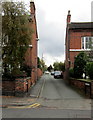
Hillfield Place, Nantwich
On the east side of the B5341 Wellington Road.
Image: © Jaggery
Taken: 13 Oct 2016
0.07 miles
3
Tanners Way, Nantwich
Cul-de-sac on the west side of the B5341 Wellington Road.
Image: © Jaggery
Taken: 13 Oct 2016
0.08 miles
4
Wellington Road houses, Nantwich
On the east side of Wellington Road, between Station View (on the left) and Hillfield Place.
Image: © Jaggery
Taken: 13 Oct 2016
0.08 miles
5
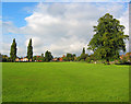
Brookfield recreational ground
Bounded by Wellington Road (right), Shrewbridge Road and the railway (beyond the line of poplars), the Brookfield recreational ground has playing fields and a small playground. On the horizon (centre) is St Mary's, the parish church of Nantwich, whose tower dominates Nantwich centre (in Image)
Image: © Espresso Addict
Taken: 3 Oct 2006
0.12 miles
6
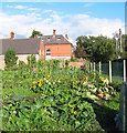
Sunflowers at Brookfield allotments
The allotments by Brookfield recreational ground back onto Wellington Road (part of the A530). The red-brick house in the background is one of the large Victorian/Edwardian houses lining that road; its tower is just visible
Image: © Espresso Addict
Taken: 3 Oct 2006
0.12 miles
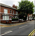
7
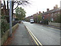
Wellington Road, Nantwich
Looking south from the level crossing.
Image: © JThomas
Taken: 12 Nov 2016
0.12 miles
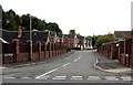
8
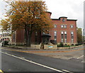
Wellington House, Nantwich
Apartments building on the corner of Station View and Wellington Road, near Nantwich railway station.
The station footbridge is on the left.
Image: © Jaggery
Taken: 13 Oct 2016
0.13 miles
9
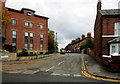
Station View, Nantwich
On the south side of Nantwich railway station, viewed across Wellington Road.
Wellington House http://www.geograph.org.uk/photo/5173205 is on the left.
Image: © Jaggery
Taken: 13 Oct 2016
0.13 miles
10
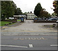
School entrance from Wellington Road, Nantwich
St Anne's Catholic Primary School is set back from the west side of Wellington Road.
Image: © Jaggery
Taken: 13 Oct 2016
0.13 miles