IMAGES TAKEN NEAR TO
Shrewbridge Road, NANTWICH, CW5 7AD
Introduction
This page details the photographs taken nearby to Shrewbridge Road, CW5 7AD by members of the Geograph project.
The Geograph project started in 2005 with the aim of publishing, organising and preserving representative images for every square kilometre of Great Britain, Ireland and the Isle of Man.

There are currently over 7.5m images from over14,400 individuals and you can help contribute to the project by visiting https://www.geograph.org.uk
Image Map
Images are licensed for reuse under creativecommons.org/licenses/by-sa/2.0
Notes
- Clicking on the map will re-center to the selected point.
- The higher the marker number, the further away the image location is from the centre of the postcode.
Image Listing (38 Images Found)
Images are licensed for reuse under creativecommons.org/licenses/by-sa/2.0
Image
Details
Distance
1
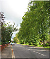
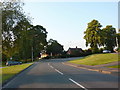
Limes lining Park Road
A mature row of limes line the A530 on the main route into Nantwich from the south. The street appears quiet, but is often busy with lorries and tractors
Image: © Espresso Addict
Taken: 3 Oct 2006
0.06 miles
2
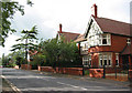
Park Road, South Nantwich
The large red-brick houses on the north side of Park Road are typical of the older houses in this area of south Nantwich. The pleasant street is lined with trees (out of frame on left), but being part of the A530 is heavily used
Image: © Espresso Addict
Taken: 3 Oct 2006
0.06 miles
3
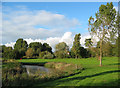
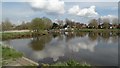
Recreational land by the Weaver
An extensive area of recreational land with grass and mature trees lies between the River Weaver and Shrewbridge Road, to the south west of Nantwich. There are several pools, possibly formerly tributaries of the Weaver. Cycle paths run through, providing safe routes into the centre of Nantwich
Image: © Espresso Addict
Taken: 3 Oct 2006
0.08 miles
4
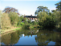
Pool, by Shrewbridge Road
Part of an extensive recreation area with several pools by the River Weaver. The red-brick Victorian terrace on Shrewbridge Road in the background runs along the boundary with Image
Image: © Espresso Addict
Taken: 3 Oct 2006
0.08 miles

8

Memorial to US airman
1st Lieutenant Arthur L Brown of the USAAF, while engaged in high-altitude flying to test oxygen equipment, crashed his Thunderbolt on this spot on the banks of the Weaver on 14 January 1944, avoiding Nantwich town centre. The plane was buried and was not recoverable. This memorial was erected in 1994, and reads:
"Here lies 1st Lieutenant/ Arthur L. Brown/ U.S.A.A.F./ aged 23 years/ of New York/ who crashed/ in his Thunderbolt/ to avoid this town/ Jan. 14th 1944/ With sympathy and respect"
For more information: http://www.pmsa.org.uk/pmsa-database/5071/
Image: © Espresso Addict
Taken: 3 Oct 2006
0.11 miles
9
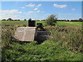
Pipe bridge over the River Weaver
The pipe is a water main, running 27km from Peckforton in Cheshire to Coopers Green reservoir in North Staffordshire. The single pipe above ground (and a similar one across the oxbow lake to the east) was seen as a serious risk to security of water supply, so in 2014/15 a £3.5 million tunnel was machine-bored to take the supply underground. But the concrete thrust blocks seen here were renewed as part of that project so presumably this pipe is still in use.
[source: http://thenantwichnews.co.uk/2014/09/08/nantwich-lake-car-park-close-river-weaver-tunnel-project/ ]
Image: © Stephen Craven
Taken: 27 Sep 2015
0.12 miles
10
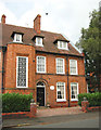
Geometric patterns at The Limes
The stairwell window is a particularly large example of the metal-framed windows in geometric patterns that are common in this area of Cheshire. Now a B&B, The Limes is named for the Image
Image: © Espresso Addict
Taken: 3 Oct 2006
0.12 miles