IMAGES TAKEN NEAR TO
Wettenhall Road, NANTWICH, CW5 6LH
Introduction
This page details the photographs taken nearby to Wettenhall Road, CW5 6LH by members of the Geograph project.
The Geograph project started in 2005 with the aim of publishing, organising and preserving representative images for every square kilometre of Great Britain, Ireland and the Isle of Man.

There are currently over 7.5m images from over14,400 individuals and you can help contribute to the project by visiting https://www.geograph.org.uk
Image Map
Images are licensed for reuse under creativecommons.org/licenses/by-sa/2.0
Notes
- Clicking on the map will re-center to the selected point.
- The higher the marker number, the further away the image location is from the centre of the postcode.
Image Listing (7 Images Found)
Images are licensed for reuse under creativecommons.org/licenses/by-sa/2.0
Image
Details
Distance
1
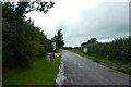
Road near Gates Farm
Looking along Wettenhall Road.
Image: © DS Pugh
Taken: 6 Aug 2023
0.04 miles
2
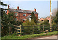
Gates Farm, near Aston juxta Mondrum
Red-brick farmhouse with timber decoration on the gables off Winsford Road; typical of larger farms in this area
Image: © Espresso Addict
Taken: 31 Mar 2007
0.07 miles
3
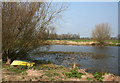
Yellow boat by mere
Mere with willows on the margin, in an arable field near Gates Farm. The largest of several meres in this square
Image: © Espresso Addict
Taken: 31 Mar 2007
0.17 miles
4
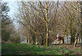
Bullocks in woodland
The public footpath (left) between Winsford Road and Stoke Hall Farm runs through a band of recently planted deciduous woodland (not shown on the OS 1:25,000 map), on top of a 55m rise in cattle pasture. A trig point is concealed by the trees (see Image)
Image: © Espresso Addict
Taken: 31 Mar 2007
0.19 miles
5
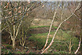
Small mere in woodland
A small mere in a hollow in a recently planted deciduous wood, one of several concealed in this band of woodland. View from the public footpath from Winsford Road to Stoke Hall Farm
Image: © Espresso Addict
Taken: 31 Mar 2007
0.19 miles
6
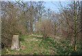
Trig point in woodland
This trig point, on the top of a 55 m rise, is located at the edge of a band of newly planted deciduous woodland (right; not shown on the OS 1:25,000) adjacent to an older strip of woodland (background). It stands near the public footpath from Winsford Road to Stoke Hall Farm
Image: © Espresso Addict
Taken: 31 Mar 2007
0.21 miles
7
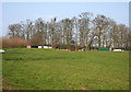
Old and new woodland
A narrow strip of old deciduous woodland housing a rookery runs beside cattle pasture from Winsford Road to the top of a 55m rise. A band of recently planted deciduous woodland runs at right angles (left; not marked on OS 1:25,000 map), concealing a trig point (see Image). The gently sloping cattle pasture in the foreground is typical of the use of the gridsquare west of the Winsford Road
Image: © Espresso Addict
Taken: 31 Mar 2007
0.21 miles