IMAGES TAKEN NEAR TO
Nantwich Road, NANTWICH, CW5 6BP
Introduction
This page details the photographs taken nearby to Nantwich Road, CW5 6BP by members of the Geograph project.
The Geograph project started in 2005 with the aim of publishing, organising and preserving representative images for every square kilometre of Great Britain, Ireland and the Isle of Man.

There are currently over 7.5m images from over14,400 individuals and you can help contribute to the project by visiting https://www.geograph.org.uk
Image Map
Images are licensed for reuse under creativecommons.org/licenses/by-sa/2.0
Notes
- Clicking on the map will re-center to the selected point.
- The higher the marker number, the further away the image location is from the centre of the postcode.
Image Listing (6 Images Found)
Images are licensed for reuse under creativecommons.org/licenses/by-sa/2.0
Image
Details
Distance
2
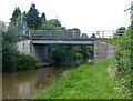
Wardle Hall bridge ( No 103 ) on the Shropshire Union canal
Taken from the stern of our boat looking towards Nantwich
Image: © Peter
Taken: 4 May 2007
0.09 miles
3
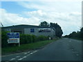
Bus Stop on the A51 near Wardle Industrial Estate
Image: © Anthony Parkes
Taken: 1 Mar 2014
0.10 miles
5
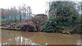
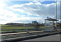
WW2 Sangar
Still watching over the Shropshire Union Canal; I think it was once part of RAF Airfield Calveley.
Image: © Douglas Cumming
Taken: 13 Dec 2016
0.14 miles
6
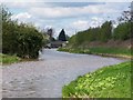
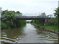
Shropshire Union Canal near Wardle Farm Bridge
Bridge 103, Wardle Hall Bridge, is visible in the distance
Image: © David Martin
Taken: 12 Apr 2012
0.19 miles