IMAGES TAKEN NEAR TO
Waterlode, NANTWICH, CW5 5XQ
Introduction
This page details the photographs taken nearby to Waterlode, CW5 5XQ by members of the Geograph project.
The Geograph project started in 2005 with the aim of publishing, organising and preserving representative images for every square kilometre of Great Britain, Ireland and the Isle of Man.

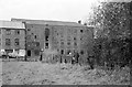
There are currently over 7.5m images from over14,400 individuals and you can help contribute to the project by visiting https://www.geograph.org.uk
Image Map
Images are licensed for reuse under creativecommons.org/licenses/by-sa/2.0
Notes
- Clicking on the map will re-center to the selected point.
- The higher the marker number, the further away the image location is from the centre of the postcode.
Image Listing (533 Images Found)
Images are licensed for reuse under creativecommons.org/licenses/by-sa/2.0
Image
Details
Distance
1
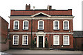
9 Mill Street, Nantwich
Grade II* listed building dating from c.1736, built as a town house and formerly Manchester & Liverpool District Bank and Nantwich Liberal Club. Currently the Residence restaurant. For more details, see [http://en.wikipedia.org/wiki/9_Mill_Street,_Nantwich]
Image: © Espresso Addict
Taken: 17 Jun 2010
0.02 miles
2
Riley's Garage, Barker Street, Nantwich
Possibly the only half-timbered vehicle workshop?
The taller building just round the corner is shown in Image
Image: © Stephen Craven
Taken: 29 Dec 1998
0.03 miles
3
Mill Island, Nantwich
This is the site of a former water mill, evidence for which dates from the 6th century and there were mill buildings here from the 13th century. The island which creates two channels on the River Weaver near the centre of the town is artificial allowing the creation of a mill stream to power the water wheel. The last mill building, a four storey structure, was destroyed by fire in 1970 and all that remains now is this small bridge.
Image: © Stephen McKay
Taken: 1 Apr 2017
0.04 miles
4
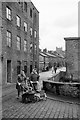
Going home past the mill, Nantwich ? 1963
This was and still is a major pedestrian and cycle access to the large council estate on the west side of the River Weaver. The mill was demolished in 1972 following a fire.
Image: © Alan Murray-Rust
Taken: 15 Sep 1963
0.04 miles
5
Nantwich Mill ? 1963
A textile mill built around 1800 on the site of a medieval corn mill, it reverted to corn milling in the late 19th century. It burnt down in 1970 and was demolished in 1972.
Image: © Alan Murray-Rust
Taken: 15 Sep 1963
0.04 miles
6
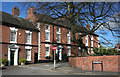
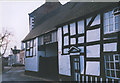
Georgian houses on Barker Street, Nantwich
Several grade-II-listed Georgian buildings stand on Barker Street near the junction with Love Lane; no. 18 is on the left, and nos 14-16 on the right. For more details, see: http://en.wikipedia.org/wiki/Listed_buildings_in_Nantwich%2C_Cheshire
Image: © Espresso Addict
Taken: 4 Mar 2008
0.05 miles
7
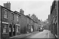
Mill Street, Nantwich ? 1963
Probably early 19th century housing development associated with the development of the nearby mill as a large textile mill.
Image: © Alan Murray-Rust
Taken: 15 Sep 1963
0.05 miles
8
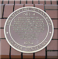
The Great Fire of Nantwich
Plaque dated 1984 marking four centuries since the Great Fire of Nantwich in 1583-4. Located on the east bank of the River Weaver at Image
Image: © Espresso Addict
Taken: 21 Feb 2007
0.05 miles
9
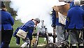
The Battle of Nantwich reinactment -Sealed Knot Society
Image: © Colin Park
Taken: 23 Jan 2016
0.05 miles
10
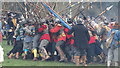
The Battle of Nantwich reinactment -Sealed Knot Society
Image: © Colin Park
Taken: 23 Jan 2016
0.05 miles