IMAGES TAKEN NEAR TO
Holland Walk, NANTWICH, CW5 5US
Introduction
This page details the photographs taken nearby to Holland Walk, CW5 5US by members of the Geograph project.
The Geograph project started in 2005 with the aim of publishing, organising and preserving representative images for every square kilometre of Great Britain, Ireland and the Isle of Man.

There are currently over 7.5m images from over14,400 individuals and you can help contribute to the project by visiting https://www.geograph.org.uk
Image Map
Images are licensed for reuse under creativecommons.org/licenses/by-sa/2.0
Notes
- Clicking on the map will re-center to the selected point.
- The higher the marker number, the further away the image location is from the centre of the postcode.
Image Listing (223 Images Found)
Images are licensed for reuse under creativecommons.org/licenses/by-sa/2.0
Image
Details
Distance
1
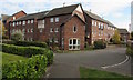
Beatty Court, Nantwich
McCarthy & Stone retirement flats in Holland Walk viewed across Red Lion Lane.
Image: © Jaggery
Taken: 26 Oct 2016
0.05 miles
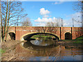
2
Across Sir Thomas Fairfax Bridge over the River Weaver, Nantwich
The bridge http://www.geograph.org.uk/photo/344916 carries the B5341 Waterlode over the River Weaver.
A plaque http://www.geograph.org.uk/photo/5172637 on the right records the opening of the bridge in March 2003.
Image: © Jaggery
Taken: 26 Oct 2016
0.05 miles
3
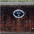
Sir Thomas Fairfax Bridge plaque, Nantwich
The plaque on the right here http://www.geograph.org.uk/photo/5172633 records the opening of the bridge in March 2003 by Bellway plc.
Image: © Jaggery
Taken: 26 Oct 2016
0.06 miles
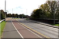
4
Sir Thomas Fairfax Bridge over the Weaver
The A534 has recently been diverted to run north of Welsh Row. The modern Sir Thomas Fairfax Bridge now carries traffic over the River Weaver, adjacent to a new housing development. The three-span, orange-brick-faced bridge has won design awards; for more information, see http://www.cheshire.gov.uk/roads/SirThomasFairfax/
Image: © Espresso Addict
Taken: 21 Feb 2007
0.06 miles
5

Path signpost alongside the B5341 Waterlode, Nantwich
Showing a quarter of a mile to Manor Road and one mile to Reaseheath College, the signpost arm points towards this path. http://www.geograph.org.uk/photo/5172617 The presence of a stile suggests that a locked gate used to be where the metal barrier is now.
Image: © Jaggery
Taken: 26 Oct 2016
0.07 miles
6
Junction of cycle paths
Looking along Water Lode. The path ahead is part of National Cycle Network route 551 with the one to the left part of 451.
Image: © DS Pugh
Taken: 6 Aug 2023
0.07 miles
7
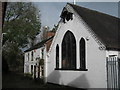
Old School, Second Wood Street
This old school in Second Wood Street is visible on the 1877 Ordnance Survey map. Other than it being a school for boys and girls I can find no other mention of it in local records.
Image: © Sue Adair
Taken: 28 Oct 2017
0.07 miles
8
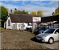
Simpson & Edge in Nantwich
Garage in Second Wood Street on the north side of Welsh Row.
Image: © Jaggery
Taken: 26 Oct 2016
0.08 miles
9
Second Wood Street, Nantwich
On the north side of Welsh Row. Simpson & Edge garage http://www.geograph.org.uk/photo/5398743 is ahead on the right.
Image: © Jaggery
Taken: 26 Oct 2016
0.08 miles
10
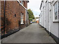
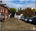
Red Lion Lane, Nantwich
On the north side of Welsh Row.
Image: © Jaggery
Taken: 26 Oct 2016
0.08 miles